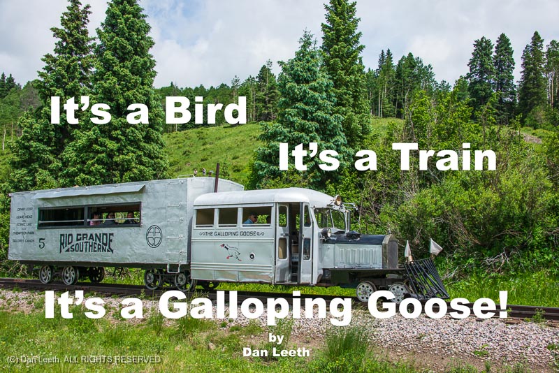
Volunteers Help to Preserve a Uniquely Colorado Slice of Railroad History

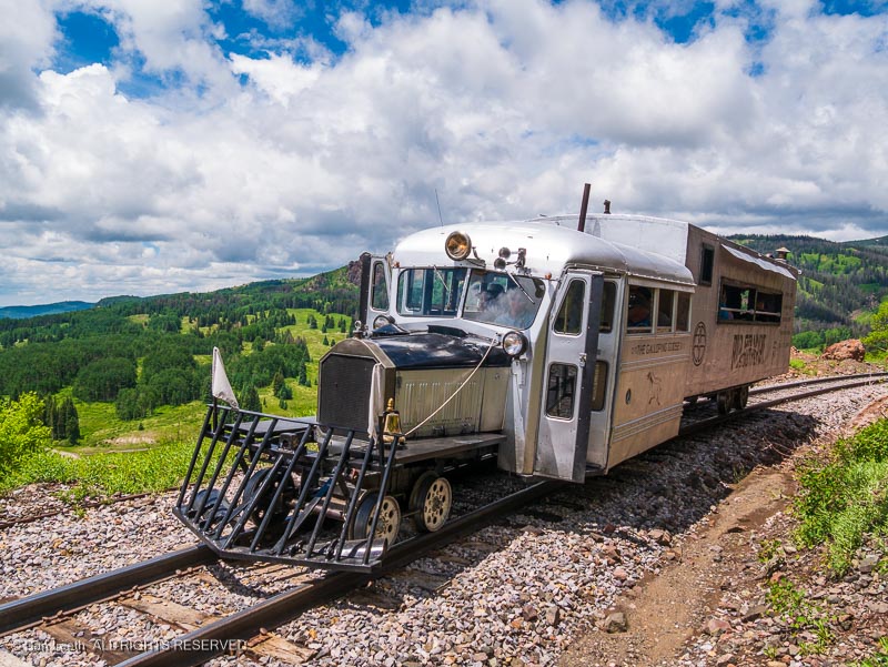
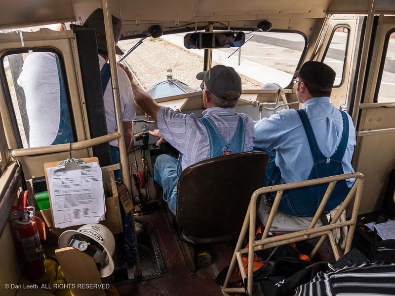
“We have to be very aware of traffic at highway grade crossings,” explains senior motorman Larry Spencer.  “We don’t look like a train.  We don’t sound like a train.  People see this coming, and they don’t recognize it as being something on rails.” 

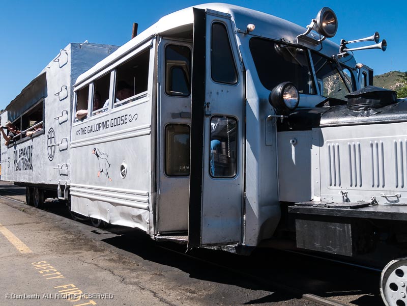
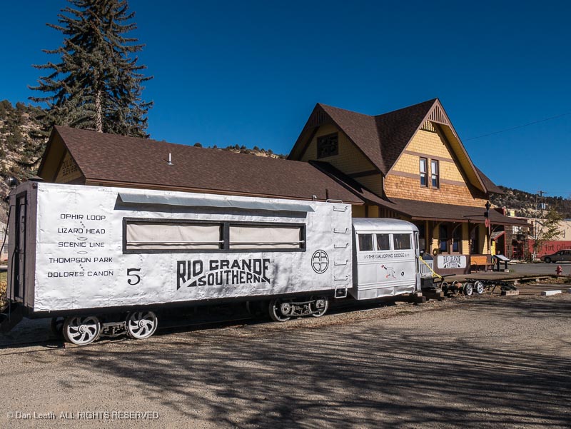
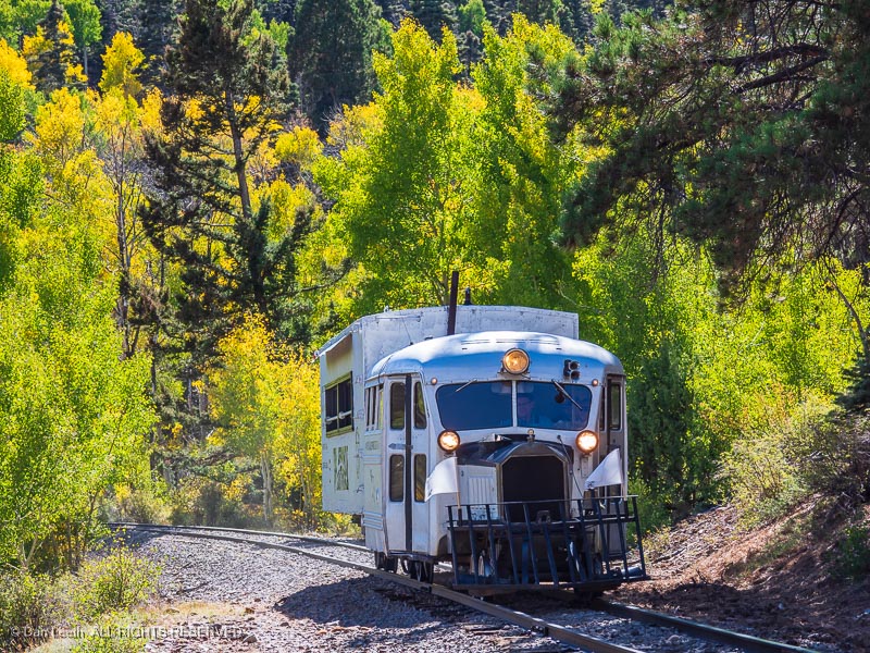
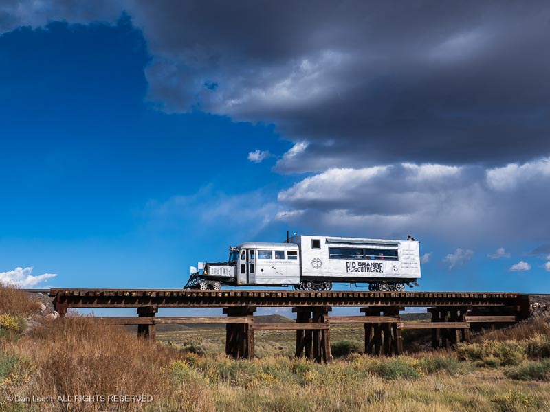
Instead of a smoke-belching locomotive, Spencer and fellow volunteers are driving Galloping Goose #5 – a silvery, rail-running contraption with a vintage auto front-end and a passenger-toting boxcar behind.  It’s one of seven such creations cobbled together during the Great Depression to keep the Rio Grande Southern Railroad (RGS) in business.

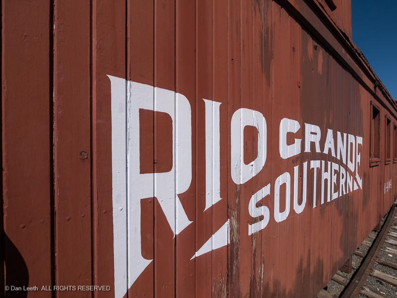
In the late 1880s, silver gushed from the San Juan Mountains of southwestern Colorado, and miners needed an economical means to haul ore out and supplies in.  To that end, Otto Mears, the famed Pathfinder of the San Juans, founded the Rio Grande Southern. 

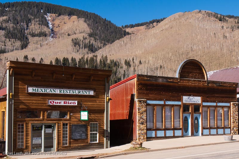
Snaking between Durango and Ridgway, it serviced the mining communities of Rico, Ophir and Telluride.  The line, which opened in 1891, immediately proved profitable.

The good times ended two years later with the repeal of the Sherman Silver Purchase Act.  Prices plummeted, mines closed, and towns emptied.  With little to carry but the mail, RGS precariously hung on.

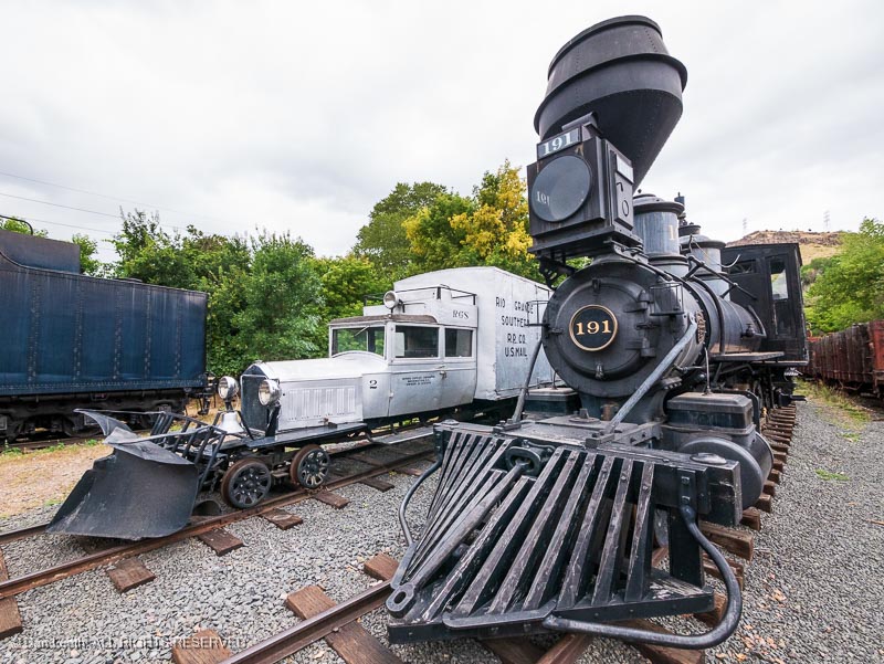
Then came the stock market crash of 1929.  Requiring a minimum of three to four employees to operate, running coal-burning stream trains over the mountains had always been an expensive proposition.  With demand further diminishing, the cost of plying the RGS route often exceeded the revenue earned.  Needing a cheaper way to conduct business, the railroad hatched their first Galloping Goose.

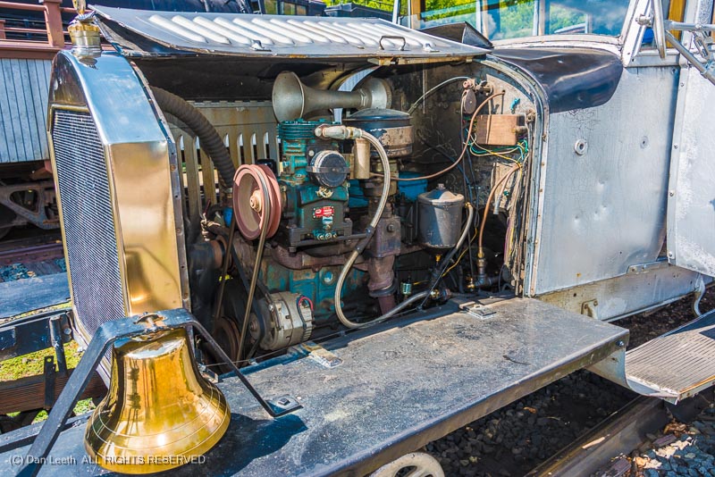
RGS crews in Ridgway took a 1925 Buick, shortened its cab, extended its frame and bolted a stake-bed platform in back to carry cargo.  They installed a swiveling rail-wheel undercarriage in front and flanged drive wheels in back.  Goose #1 hit the tracks in June 1931.

Burning cheap gasoline and requiring only one employee to operate, it paid for itself in less than a month.  A second Buick-bodied Goose came two months later with five more goslings to follow, all of which employed cast-aluminum, Pierce-Arrow bodies.

To help keep motors cool, these piston-engined creations often ran with open hood panels, which flapped like wings at speed.  The vehicles appeared to waddle on the ill-maintained RGS tracks and to some listeners, the original horns sounded like a goose with gas.  The railroad originally referred to their creations as “motors,” but it didn’t take long for folks to bestow them with their fowl moniker.

The RGS made modifications to the Geese over their two-decade life.  They replaced engines, added air brakes and resprayed their creations with longer-lasting aluminum paint.  In the late ‘40s, Geese #3, #4 and #5 had their Pierce-Arrow cabs replaced with war surplus bus bodies. 

After the RGS lost its mail contract in 1950, they cut windows into the boxcars, installed seats salvaged from Denver streetcars and tried to operate as a tourist train.  Few folks came and the railroad folded in 1952.  The Geese became orphans.

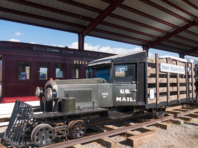
A faithful reproduction of Galloping Goose #1, which had been scrapped for parts in the ‘30s, can be seen at the Ridgway Railroad Museum. 

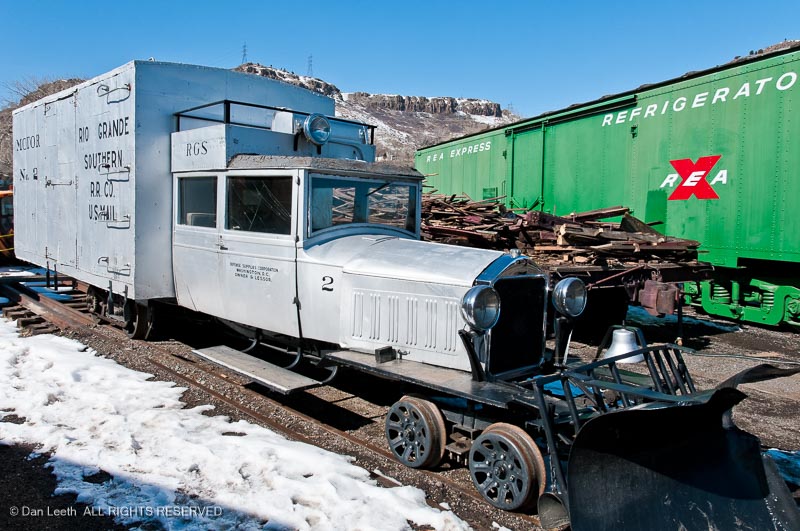
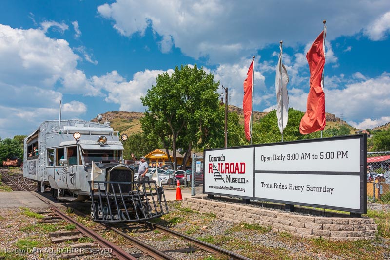
Goose #2, which originally went to Alamosa, now nests at the Colorado Railroad Museum in Golden.  Knott’s Berry Farm bought Goose #3 for their California amusement park. 

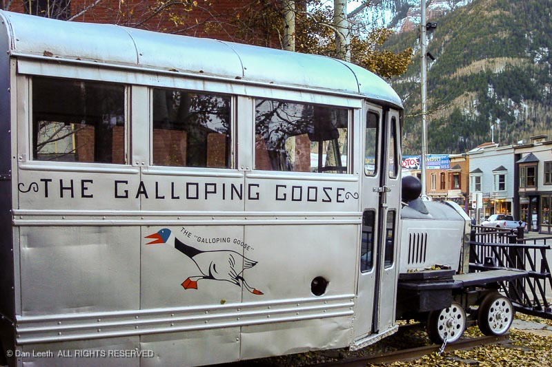
A restored Goose #4 sits in downtown Telluride, and Goose #5 fronts the Galloping Goose Museum in Dolores. 

Geese #6 and #7, which were originally used by scrappers to tear up the tracks, have also found a home at the Colorado Railroad Museum.

“Seven was in very sad condition when we got it and #6 was, too,” explains museum volunteer Al Blount.  “Both engines were completely shot.  We found three 1956 Chevy six-cylinder engines and got two of them to work.  One is in Goose #7 and the other in #6.”

A retired global nuclear service specialist, Blount saw his first Goose in the late ‘40s on a Dolores River fishing trip.  He didn’t get to ride in one back then, and when he started volunteering at the museum in 2002, none of their three Geese were operational.  Blount recruited volunteers and personally took on the Goose restoration project.  By 2008, they had all three running.

“Some parts we had to manufacture ourselves,” he recounts.  “You can’t go down to a Pierce-Arrow dealer and buy something.  You have to make quite a bit.”

The upholstery in Goose #7 was unrecognizably rotten, but Blount discovered a usable sample of the original hidden behind some wood.  He found a near match, and using 14½ yards of fabric, he personally sewed the replacement upholstery himself.

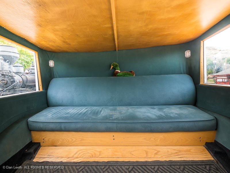
“It took a while to do it.  I would have to sew something at home, come down and see how it fit and then go back and make alterations.”

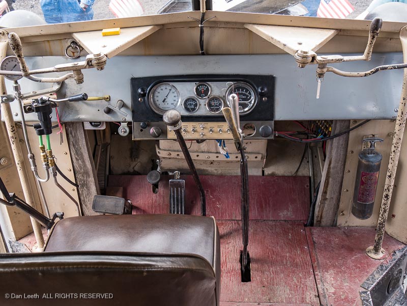
While the upholstery is close to the original, the volunteers had a little fun with other parts of their restoration efforts.  The dashboard of Goose #6, for example, appears to hold an aircraft air speed indicator and an altimeter.

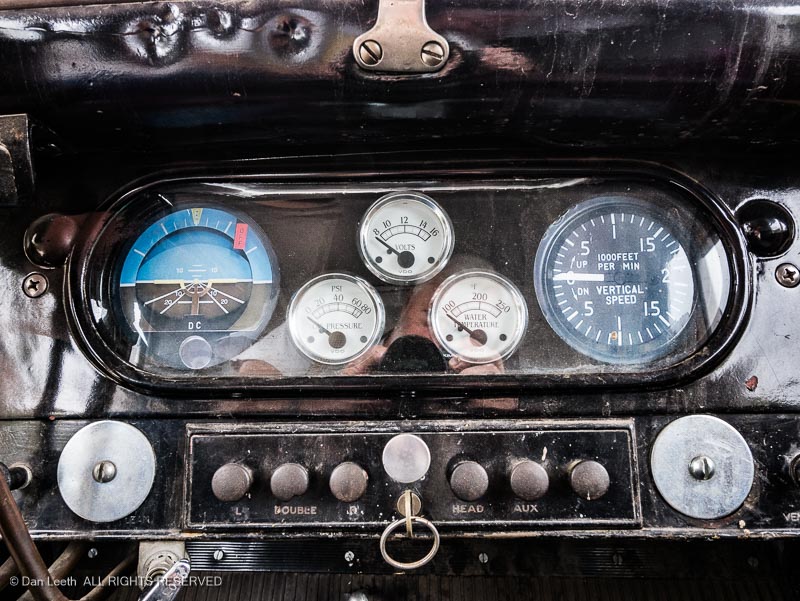
“They’re nothing but pieces of paper glued on the dash,” laughs Blount.  “Our Geese don’t fly that high.”

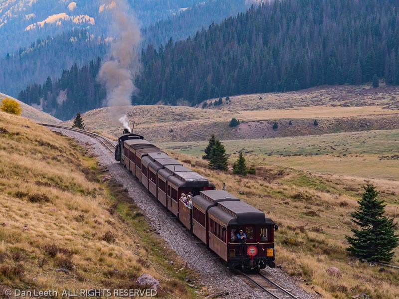
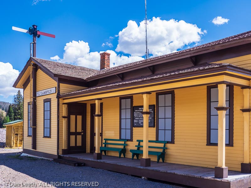
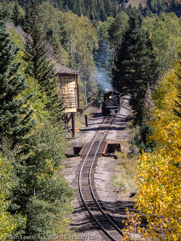
For those who would like to take a jaunt in a Goose, the Colorado Rail Museum frequently offers three-lap rides in Goose #7 around their 1/3rd of a mile circuit.  For longer excursions, the Galloping Goose Historical Society in Dolores periodically runs Goose #5 down the scenic Durango & Silverton and Cumbres & Toltec tracks.

“Our Fall Color Special on the Cumbres & Toltec is pretty spectacular,” brags society president Lou Matis.

Like the driver of a bus, the motorman sits at the left front.  There’s a clutch pedal and accelerator on the floor, a gear shift lever to the right and a rear-view mirror overhead.  What’s missing is a steering wheel.  The Goose boasts a five-speed transmission and a 140-horsepower, GMC straight-six engine capable of pulling its eight tons up four-percent mountain grades.

“It’s geared in such a way that the top speed on this is about 45 mph, but we’re limited to 20,” explains senior motorman Larry Spencer.  “Above that we start to oscillate with the front section going one way and the back the other.”

Spencer, a retired Denver firefighter, developed a lifelong fascination of railroading, especially narrow gauge railroading.  On family vacations to Ouray, his father and brother often explored the Rio Grande Southern railroad grades, which had only been abandoned a few years.

“In 1999, a good friend of mine belonged to the Galloping Goose Historical Society and asked if I would like to come down for a ride.  I got hooked,” he recounts.  “Since then, I’ve done maintenance, learned to drive and been a motorman for about eight years now.  I’ve driven all of the existing Geese except Knott’s Berry Farm’s #3.  They wouldn’t let me because I wasn’t an employee.  I wanted them to put me on the payroll for ten minutes, but they had very strict rules.”

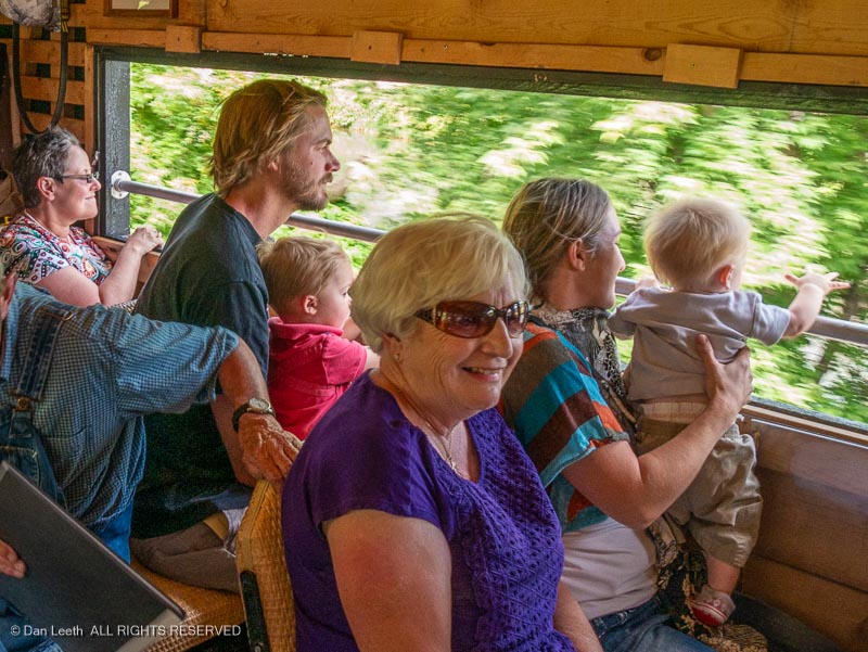
Running with doors open and no glass in back, passengers hear the pounding of the engine, the whine of the transmission and the clacking of wheels on rails.  Whistles blow and bells ring at every roadway crossing.  Cars stop and people stand beside the tracks, waving and taking photos.

It doesn’t look like a train.  It doesn’t sound like a train.  The surprised looks on faces suggest most probably have never seen a Goose galloping down the rails.

[Story originally appeared in the September-October 2016 issue
of Colorado Life magazine]


Over the years, I’ve taken many well organized motor coach tours.  This was not one of them.

It began in Casablanca, Morocco, where I had a day to spare.  Considering alternatives for passing the time, I ended up choosing an all-day tour to Marrakech.  It would not allow much opportunity for exploration, but at least I would get a taste of Morocco’s red city in the desert.

The trip departed in predawn darkness.  Bleary-eyed and caffeine-deprived, I stumbled aboard the idling bus.  Grabbing a pair of empty seats near the back, I curled feline-like into a dozing, semicomatose ball.  I failed to notice that a speaker hung immediately overhead.

 “Nice to meet you all,” an amplified voice boomed inches from my ear.  “My name is Mohammed.  I’m your guide.”

Perhaps in his 40s, Mohammed stood six feet tall, sported a bushy mustache and wore a blue sharkskin suit.  Like a hyperactive child, he yacked nonstop for the entire four-hour drive to Marrakech.  Although we mostly heard about his friends, siblings, home, education and pet dog, Mohammed did relate a bit about this North African homeland.  We found out about meats in the local diet, received lessons on how to make couscous and learned that the average Moroccan consumes 80 pounds of sugar annually.

“That’s why our women are very fat,” the guide snickered.

Mohammed’s favorite subject was polygamy.  Under Islamic law, he said that a man can have up to four wives.  His neighbor, he boasted, has two spouses and 24 children.  Twenty-three are boys.

“The daughter, of course, does all the work around the house.”

A passenger asked the guide how many wives he had.  Mohammed stammered, then admitted he possessed but a single spouse.

“One wife is good,” the man rationalized.  “Two wives is problem.  Three wives, more problems.  Four wives is war.”

While the guide bantered, I stared at the countryside flashing by.  At first fields and farms lined both sides of the highway, but the cropland soon merged into desert.  Unlike the dune-draped landscape depicted in “Lawrence of Arabia,” this part of the western Sahara looked more like Arizona with rolling hills, rock outcropping and barren mountains.  Sheep and goats foraged among prickly pear cacti.  The same spiny plants served as living fences around the isolated Berber home sites.

By midmorning, the salmon-pink buildings of Marrakech loomed into view.  With its core dating back nearly a thousand years, the city presents a fascinating homogenization of old and new.  Modern apartments stand near timeworn hovels, and Mercedes sedans share the pavement with donkey-drawn wagons.  Passing columns of cars, carts and camels, we arrived at our first Marrakech attraction, the Ménara Gardens.

“I beg you to stay together in one group,” Mohammed pleaded.  “If we lose somebody, it will take three days to get him back.”

The Ménara Gardens feature over 200 acres of olive orchards, flowers and shrubs, but we scarcely saw any of them.  We came to view only the site’s 12th-century swimming pool.

“Quick.  Out of the bus,” Mohammed prodded.

With the speed of a Florida recount, 38 passengers oozed from the coach.  Marching armpit to armpit, we followed our leader toward a rectangular pond spacious enough to hold a quartet of football gridirons.

“Before the Moors invaded Spain,” Mohammed told us, “they needed to teach desert soldiers how to swim.  So they built this big stone pool.  Now I show you surprise.”

Our guide tossed bread into the opaque water.  The chunks floated like marshmallows in a cup of chocolate. 

“Watch!” Mohammed smiled.

Nothing happened.

“No.  You watch.”

After a 90-second eternity, a foot-long carp surfaced.  Like a junior version of jaws, it lunged at the drifting delicacy.  Its piscine partners soon joined the fray.  In one brief feeding frenzy, the morsel disappeared.  The show was over.

“Everybody, back on the bus,” our drill sergeant ordered.  “Hurry.  We have other places to go.”

We continued to the Koutoubia Mosque.  Also completed in the 12th century, this structure replaced an earlier mosque that occupied nearly the same spot.  In an engineering snafu reminiscent of today, it turned out the original house of worship was misaligned with Mecca.

“Let’s go,” Mohammed commanded.  “Five minutes to get beautiful picture.”

 We dribbled out, dodged traffic and walked to where we could view the 220-foot-high minaret.  When new, plaster and decoration covered the tower.  Now weathered nude, its walls exposed pinkish sandstone underpinnings.

“Everybody get photo?  Good.  Now, back to the bus.”

Turning to leave, we ran straight into three men dressed in red sequined with polished brass cups.  These were the famed water sellers of Marrakech.  Historically, the vendors peddled precious liquid squirted from a bag.  Now, they profit by posing for pictures.  I removed my lens cap and reached for a few dollar bills.

“No time!”  Mohammed shouted as he shooed them off.

The tour proceeded to the Bahia Palace built in the 1800s.  Empty now, it was once home of the sultan’s vizier, or “prime minister” as Mohammed called him.We blitzed down passageways and through courtyards, gardens, pavilions and reception halls.  Although now in need of restoration, the edifice with its carved and gilded Moorish ceilings, must have once looked more ornate than the Playboy Mansion.

Mohammed led us into the master quarters.  With the fervor of the “National Enquirer,” he revealed how the former owner had four wives and dozens of concubines.  Grinning, he explained how a bedroom band would play for each soiree, their backs discretely turned.  It sounded like the legend of an Arab Hugh Hefner.

Our next stop was the Saadian Tombs, a necropolis dating back to 1557.  Stone-covered graves lie in a quiet enclave shaded by trees, shrubs and rosemary hedges.  Two pillared mausoleums extend beyond.  In this, one of the most visited shrines in Marrakech, we spent 15 minutes.

“Now we go shopping!” Mohammed announced.

Our guide marched us down side streets and into an alley that doubled as the local urinal.  Through an unmarked door, we walked into a rug shop.

“Good buys here,” Mohammed hyped.  “Go sit.”

My cohorts and I dutifully planted ourselves on benches.  While women distributed cups of mint tea, a master salesman and his assistants tossed rugs across the floor.  The brew was sweet and the designs exquisite, but I wanted to meet people.  When Mohammed looked away, I escaped.

In a small square behind the shop, five boys played with string-thrown tops.  Two younger girls watched from an apartment doorway.  I held up my camera, seeking permission to take their photograph.  The older girl smiled, then started preening her sister’s hair for the picture.     

The boys soon came over.  The older one, a lad of about 10, showed me his soccer cards and told me the names of the players.  At least I think that’s what he was saying.  I didn’t understand a word, but that didn’t deter our conversation.  I let the kids look through the camera.  They giggled, excitedly hogging the viewfinder.

The tour spent more time in the rug shop than at all previous sites combined.  Clearly, Mohammed wanted his commission maximized.  I rejoined the group after the last passenger finished negotiating her purchase.  Only when we finally departed did one man discover that his wife was missing.

 “Don’t worry.  We go to lunch now,” the guide blithely announced.  “I know how to handle this problem.”

The husband and Mohammed’s local assistant went to find the wayward woman.  The rest of us headed for a tourist restaurant.  Inside, a trio of bored musicians played while we devoured salad, bread, chicken and couscous.

A busty belly dancer followed dessert.  Practically popping from her top, she swiveled and gyrated to Moroccan riffs.  Nearly every male had a camera flashing or camcorder rolling.

After lunch, we visited Place Djemaa el-Fna, the city’s bewitching central square.  The place buzzed with life.  Local men and women, garbed in full-length robes called djellabas, sauntered by.  Scarves covered women’s heads, and veils often hid their faces.  Capping the men, I saw more fezzes than at a Shriners’ convention.

Snake charmers, monkey handlers, storytellers and scribes entertained on the cement.  I watched one young man perform with cobras and a pit viper.  He draped the reptiles over himself and kissed their fanged heads.  The charmer hammed it up as I snapped gift photos for my snake-hating friends.

I wanted to wander farther and visit Marrakech’s famed souks, the city’s winding market alleyways crammed with merchants who boisterously hawk wares.  But, Mohammed would not allow it.  Twenty minutes after we arrived, the trail boss started herding us toward his motor coach corral.

“If we leave now, I can give you an extra half hour in a fine shop,” Mohammed offered.  “Fixed price.  No haggling.”

Reluctantly, I reboarded the bus.  At least with Mohammed busy compounding commissions, I might still enjoy one final unguided encounter in the magic of Marrakech.

Whoever invented the sport of skeleton must have suffered from loose bones in the brain. 

            Take a steel-framed sled that’s about a yard long and inches high.  Place it on an ice-plastered, concrete bobsled track with banked corners capable of exerting 5-g centrifugal forces.  Push off, and like a bowling ball careening down a laundry chute, slide down headfirst at freeway-worthy speeds. 

            I can’t wait to try it.

            Along with bobsled and biathlon, sampling skeleton is one of the Olympic Legacy Package options offered through the Four Seasons Hotel at British Columbia’s Whistler Blackcomb ski resort.

            Home to the 2010 Olympic alpine, Nordic and sliding events, Whistler remains one of North America’s largest single ski area with terrain ranging from groomers to glaciers.  It boasts a mile of vertical relief, one of the greatest drops on the continent.  I spend my arrival day sliding the slopes like gold-medalist Bode Miller, but at a quarter the speed and a fraction the form.

            My first Olympic Legacy event is the Discover Biathlon Experience held at Whistler Olympic Park in Callaghan Valley, a 20-minute drive from the village.

            In men’s Olympic competition, instructor Jessica Blenkam explains, cross-country skiers race a four-kilometer course which ends at the shooting range.  With hearts pumping at a rate that would send Richard Simmons to the ER, the athletes fire five shots at tiny targets.  For every miss, they do a 150-meter penalty lap.  They then ski another four-kilometer loop and fire again.  In all, they do five loops and four firing sessions – two standing and two prone. 

            “First, we’re going to do a little bit of a skate ski lesson,” Jessica outlines.  “Then we’re going to do some marksmanship.”

            While I downhill and have a long history of classic, kick-and-glide cross country skiing, I’ve never skate skied.  Jessica shows me how to balance, how to push off, how to pole and how to turn.  She does her best to provide positive reinforcement.  

            “You’re really good at getting up after falling!” she exclaims.  “And wow, you still have both your skis on.  Good job!”

            After an hour spent trying to master skate skiing, it’s time to shoot.  At the 30-lane firing range, a mat and rifle await me at station five.

            “Those targets are 50 meters away,” Jessica points out.  “The standing targets are the size of a grapefruit, and the prone are the size of a plum.”

            The rifle is a Russian-made .22 caliber specially built for biathlon with bullets enclosed in five-shot clips.  Jessica assures me that it’s very similar to what the athletes use, although theirs would probably have a carbon-fiber stock specially fitted to their bodies and cost thousands of rubles more.

            “This is similar to a bolt action, but it’s called a Fortner action,” she explains.  “It’s designed to fire accurately and perform well in cold, wet conditions.  We’ve zeroed the rifles in so they’re dead accurate.”

            Lying on my belly, I center the first circle in the sights.  Gently, I squeeze the trigger.  The shot echoes, but the target remains black. 

            I missed.

            I fire again.  And again.  By the time the clip is exhausted, only two targets have turned white.  Over the course of the next hour, my best result is four out of five, and I don’t have to ski before firing.  Maybe biathlon will not be my podium event.

            Back in town, I wander the pedestrian-friendly village, which feels like a huge outdoor shopping mall.  Overall, Whistler boasts 9,500 permanent residents and 11,500 second home owners.  There are at least 24 hotels and enough timeshares and condos to house more than 30,000 visitors at one time.  The area boasts 200+ retail shops, 90+ restaurants and cafes, 30+ bars and lounges and 20+ spas.  All fit together in architectural harmony, each painted in its own shade of brown.

            “There’s a very specific look and feel that you have to have when you’re opening a business in the resort,” admits tourism official Kerry Duff.

            Built in 2004, the Four Seasons is one of Whistler’s newer hotels.  It bills itself as a 273-room, rustic modern retreat, and along with the Ritz-Carlton in Toronto, remains one of only two AAA Five-Diamond hotels in all of Canada.  Located in Upper Village on the Blackcomb side, it’s not ski-in/ski-out, but they do offer free shuttle service to a slope-hugging ski valet center.

            That evening, I hit the Four Seasons Spa and splurge on a heat-therapy treatment originally created for the Olympics.  Now called the “Spirit of Whistler,” it began as “On the Podium.”

            “When the treatment was created, the spirit at the time was the Olympics,” explains spa director Filipa Batalha. 

            It’s too bad they changed the name.  It might have been the closest I’ll ever get to an Olympic podium.

            The next day, I head over to the Whistler Sliding Center, site of the Olympic bobsled, luge and skeleton track.  It’s nearly a mile in length, sports a 499-foot drop with an average grade of 10.5%.  Its 16 corners culminate with Thunderbird, a nearly 180-degree hairpin turn where sleds and sliders experience maximum speeds and G-forces. 

            “You’re all going to be active participants in the sport of skeleton today,” Anna Lynch tells us at orientation.  “You’re going to reach speeds up to 100 kilometers per hour and experience G-forces several times your body weight.”

            She shows us the sleds, which look nothing like the Flexible Flyers of my youth.  There’s a cutout at the top where our heads go.  Our torsos cover the middle part.  Arms go down the side and hands grip handles beside our butts.  Knees rest on a plate near the bottom. 

            “Be like a sack of potatoes,” Anna advises.  “If you lift your knees or shoulders, the runners are going to be free to move side to side.  That’s when you’re going to be tapping the walls.  You want to keep a nice streamlined body position at all times.  No chicken wings.”

            Unlike Olympians who dive onto moving sleds from the top, we start stationary and descend only the bottom third of the track.  Anna gives us our starting order.  I’m number eight.

            My time comes all too soon.  Lying in wait, I’m more nervous than the groom at a shotgun wedding.

            “You ready?” the starter asks. 

            Sack of potatoes.  Only 30 seconds of sheer terror.

            “Sure,” I gulp. 

            He pushes and I begin accelerating down the track faster than a nitro-flaming dragster.  Through goggles, all I see is a whirring blur of gray ice.  Centrifugal force slams my helmet down causing the chin guard to scrape the surface.  Instinctively, I lift.  The sled weaves and I begin caroming off the walls.  I make promises I’ll never keep.

            Finally, I fling through Thunderbird and stop on the uphill outrun.  Like a pilot walking away from a crash, I feel lucky to be alive.

            My time is 32:61.  After all 20 participants finish their first runs, I’m in 18th place.  With two others worse than me, I’m as ecstatic as a nerd who’s suddenly not the last kid chosen for the team.

            Exercising better control on my second run, I cut more than two seconds off my time and shoot through the speed trap a hair under 60 mph.  That gives me 14th place.

            Maybe skeleton will not be my podium event, either.  There’s still the final Olympic Legacy option of bobsledding left to do.

A Cruise to the Antarctic Circle Takes Voyagers Past the Last Land on Earth

            Two nautical charts lie spread across the ship’s navigation table.  Both indicate we are traversing “unsurveyed waters.”  Concerned, the captain maintains a heading that overlaps a solitary line of depth soundings.  Although a veteran of Antarctic waters, he has never before sailed this channel.

            Visibility diminishes with dusk.  Heavy snow begins to fall.  The dime-sized flakes plaster windows on the bridge making it difficult to discern the icebergs that clog the channel.  The floating obstacles, however, show clearly on radar.  Images of ice paint the monitor with splotches of cold orange. 

            One massive, tangerine glob looms dead ahead.  The scale registers a distance of three kilometers. 

            Then two.  

            At one kilometer, the captain breaks the silence with a whispered order.  The helmsman flicks the wheel, and the ship begins angling. 

            Through a shroud of fog and snow, a ghostly apparition reveals itself as a tabular iceberg, a form unique to the Southern Ocean.  Its sheer sides rise a hundred feet to a top that stretches flat and wide as a Kansas homestead.  Once again, I stand awestruck by the humbling magnitude of Antarctica.

            Our polar-class cruise vessel is bound for the Antarctic Circle, the dashed line that girds the bottom of the globe.  The route there takes us past the most remote and uninhabited land on the planet. 

            Antarctica was not sighted until 1820.  Another 79 years passed before anyone wintered on its surface.  Explorers soon arrived in a deadly quest for the southern pole.  Scientists followed.  Until recently, the land’s only tourists were those who could afford five-figure fares.  Now, prices have plummeted, and for about the cost of a Caribbean escapade, I booked a Marine Expeditions’ cruise to the seventh continent. 

            Antarctica is shaped like a manta ray with a curving tail.  A 600-mile stretch of ocean separates the stinging end from the tip of South America.  Through this gap known as the Drake Passage churn the roughest seas on earth.  Negotiating the “Slobbering Jaws of Hell” is the true toll of admission to the last land on earth. 

            “Stow everything before you turn in,” the guides warn.  “Also, securely latch cabin portholes.”

            Leaving from Ushuaia, the Argentine city on Tierra del Fuego, the ship first navigates the placid waters of the Beagle Channel.  Then, sometime in predawn darkness, we hit the open ocean. 

            For two days we do the Drake Shake, rocking and rolling through latitudes where no appreciable land tempers nautical might.  Winds howl at near gale force.  Waves explode over the bow, sending a shrapnel of ocean spray higher than my fourth deck window.  Swells rise between 15 and 40 feet, their estimated size varying with the amount of sea sickness the observer is suffering. 

            “This is not too bad for the Drake,” a staff member assures me.  “I’d say it is fairly typical.” 

            Our second day from South America, we enter the cold waters of the Southern Ocean.  The following morning, I awaken to views of a coastal archipelago.  Sedated by land, the seas have calmed to a gentle chop.  Wisps of cloud float around mile-high summits.  Angular ridges poke like chocolate shards from glacial frosting.  Cracked, fissured, smooth and choppy, the ice flows in frozen slabs to the sea.  It looks as though a range of Everests jut straight from ocean blue.

            “This is like childbirth,” observes one motherly passenger.  “Getting here is labor.  Now we cradle the joy of parenthood.”

            An unruly child, Antarctica is on average the coldest, windiest, highest and driest of the seven continents.  Although its surface holds 70 percent of the world’s fresh water, the polar plateau receives about the same precipitation as Death Valley.  Owned by no one, the land has no indigenous human population, and animals visit only briefly to molt and reproduce.  It remains the only continent without a Holiday Inn.

            In this region of extremes, sailing routes depend on weather, and shore landings are at the whim of wind and waves.  Although the guides advise us to be flexible, our initial landfall comes on schedule. 

            We assemble on deck in predesignated groups.  When mine is called, I join nine others in an inflatable Zodiac.  The driver guns the outboard, and a quarter mile later, we bump dry land.  With one step, I join the exclusive fraternity of people who have touched Antarctica. 

            Our first frat party is a black-tie affair hosted by a delegation of two-foot-tall penguins.  Garbed in feathery tuxedos, they strut like aristocrats at a fund raiser.  The majority of residents are chicks still covered in gray down, but a few adolescents are beginning to sprout head feathers.  The hairdos make them look as bizarre as punk rockers at an opera. 

            At nearby Paradise Harbor, we take Zodiacs on a cruise through an inlet cul-de-sac that resembles an intimate version of Alaska’s Glacier Bay.  Towering crags scrape the sky.  Blankets of frozen ice drape the cirque in curtains of crystal blue.  Miniature bergs reflect in mirror-still water. 

            We glide past Antarctic shags, which nest on a plunging cliff.  Nearby, thick flocks of terns flutter in the air.  Crabeater seals lounge on an ice floe.  We approach, quietly sneaking photos like a boatload of paparazzi.  The natives seem unfazed by our bold intrusion. 

            Outdoor temperatures along the peninsula typically hover around freezing, and a few layers of ski clothing provide comfortable warmth.  One evening, we even enjoy an outdoor, deck-top barbecue.  The chefs grill steaks, chicken, burgers and brats while the bartender mixes drinks with ice chipped from the remnants of a small berg.  This is one picnic where brews stay cold, and ants definitely are not a problem.  

            Continuing south, we pass through the Lemaire Channel, a fjord-like corridor nicknamed “Kodak Gap.”  Here, glistening mountains ascend from the ocean in postcard-perfect artistry.  It looks as though we are sailing through the Alps after the Great Flood.  The view is nearly identical to that seen by the first mariners who plied these waters.  Apart from a handful of science bases, Antarctica remains virtually untrammeled by humankind. 

            We visit one of the continent’s earlier research stations at Port Lockroy.  Built by the British during World War II, it provided reconnaissance and weather data.  The main hut, Bransfield House, remains the oldest British structure on the peninsula.

            Now a historic site, Port Lockroy offers a glimpse of Antarctic life from a half-century past.  The unpretentious buildings were made of wood, heat came from coal-burning stoves, and communication with the outside world was by vacuum-tube radio.  Originally a crew of nine lived in spartan quarters.  Now a pair of Antarctic veterans spend the austral summer refurbishing the facility.  They also vend clothing, patches, stamps and postcards. 

            “We get over 40 tour boats each season,” says one of the pair.  “The money we collect goes toward restoration. 

            While Antarctica is becoming a more popular destination, the continent still gets only about 10,000 visitors each year.  Trip organizers have formed the International Association of Antarctica Tour Operators (IAATO) to self-regulate tourism.  Members pledge to travel safely, protect wildlife, respect protected and scientific areas and help keep earth’s last true wilderness pristine.

            We stop at Petermann Island where the peninsula’s three species of penguins peacefully share an integrated neighborhood.  Gentoos have snowy earmuff flashes that cross their heads from one eye to the other.  Chinstraps sport black skull caps seemingly held in place by a thin line below their beaks.  Adélies feature black noggins with their eyes ringed in white.

            As we head south, we spy more wildlife from the ship’s bridge.  Through its windows, I glimpse whales shooting plumes of vapor from blowholes.  Above the surface, albatrosses soar on glider wings.  Skuas and kelp gulls add to the aerial display. 

            When wildlife is absent, I admire the floating gallery of sculpted icebergs.  Some look like Monument Valley monoliths.  Others are honed and weathered like salt licks.  Many glisten Clorox white, their ice still marbled with trapped air.  The rest show pale blue, dense from years of glacial compression.  Nearly all display a band of eerie luminescence that shimmers below the waterline like neon glowing beneath a low-rider. 

            The iceberg flotilla increases as we head farther south.  I watch our progress on the Global Positioning System’s digital display.  At a bleary-eyed 2:40 in the morning, the ship reaches 66 degrees, 30 minutes southern latitude.  We cross the circle and enter the south polar world.

            A few hours after dawn, we take Zodiacs to windswept Detaille Island.  A British research station once operated here.  Frequently frozen in, even the tenacious Brits gave up and left years ago.  Their buildings remain. 

            Near the structures, Adélie penguins waddle up a snow slope, then toboggan down on their bellies.  A hundred yards away, fur seals growl at each other.  These animals have the disposition of a linebacker, are aggressive as Ken Starr and bear the teeth of Mike Tyson.  Unlike other seals, they can run on their flippers.  We maintain our distance.

            One passenger found an old bicycle onboard, and he has it hauled ashore.  A few of us take turns posing as polar pedalers atop the two-wheeler.  For two hours, we goof-off, explore the island and view its wildlife.  Finally, time comes to return.  The crew hoists the Zodiacs aboard, and the ship turns north. 

            From his place on the bridge, the captain smiles.  A look of relief seems to cover his face.  The waters here may be unsurveyed, but he now brandishes the confidence of having sailed this way before. 

Québec City Provides a Dreamy Retreat in the Dead of Winter

            Maybe it’s because I grew up beneath the sweltering Arizona sun, but I find myself irrepressibly drawn to cold places.  Give me frosty air and a few flakes on the ground, and I’m as happy as a penguin on ice.  When it comes time to treat my wife, Dianne, to a romantic, midwinter getaway, I book a return visit to Québec City.

            Founded a dozen years before the Pilgrims hit Plymouth Rock, Old Québec City’s stone walls enclose a downtown filled with picturesque shops, pubs, churches, restaurants, hostelries and residential row houses.  French is the language with English freely spoken, albeit with a syrupy accent.  And being Canadian, folks here are friendly and polite.  Here, we can enjoy Euro-flair with less time in the air.

            The Québécois don’t let the cold get them down.  The town remains fully functional in winter.  Vendors still sell art in outdoor galleries, horse-drawn carriages still clomp up cobblestone streets and sidewalk cafes still offer alfresco lunches.  Best of all, it’s a place my heat-hating spouse truly enjoys visiting.

            “Fantastic!” Dianne exclaims, “as long as we can stay in the Frontenac.”

            Chateau Frontenac, now a Fairmont Hotel, stands as the structural icon of Québec City.  It was built in the 1890s by the Canadian Pacific Railroad to lure clients into luxury travel by train.  With turrets and towers reminiscent of the Middle Ages, the 611-room edifice looks like a fairytale castle at the edge of the bluffs above the Saint Lawrence River.  One almost expects to see Tinker Bell fluttering about.

            “We’ll have a few nights at the Chateau,” I assure my mate, “but I’ve got an even more romantic surprise for the last night of our trip.”

            We arrive at the Chateau Frontenac and check in.  I’m looking forward to sharing an amorous first night’s dinner with my lovely at the hotel’s Restaurant Champlain, but those plans quickly evaporate.

            “Where’s the best place around here to get poutine?” Dianne asks the concierge.

            Invented in Québec, poutine is a Canadian specialty, which like ketchup-flavored potato chips, is seldom seen south of the 49th parallel.  It consists of French-fried potatoes topped with cheese curds and smothered in gravy.  The saturated fat content alone would make a cardiologist wince, but that doesn’t bother my dining partner, a 30-year nurse.  She’s so fond of the dish, she even uses a photo of poutine as the desktop background on her computer.

            “Chez Ashton has the best poutine by far,” the concierge claims, handing her a map with this mecca of malevolent nutrition circled.  Instead of china and stemware, we eat dinner from aluminum pie plates at what could pass as a French-Canadian version of Chipotle’s.  Fortunately, they sell beer.

            “Thank you!” Dianne coos as we depart, arm in arm.

            Last time we came to Québec City, we packed skis and drove to the Charlevoix region to slide the slopes of the Le Massif Ski area.  This time, I’m taking my ski-free honey to Charlevoix by train.

            Le Massif and Le Train le Massif de Charlevoix are owned by Daniel Gauthier, who along with Guy Laliberté founded Cirque du Soleil.  After selling his interest in the circus, Gauthier bought the ski area and reestablished the rail route along the banks of the Saint Lawrence River.

            We board near Montmorency Falls, a 272-foot-high chunk of ice that’s one and a half times higher than Niagara.  Climbers arrive with ropes and packs presumably filled with warm clothes.  It’s five degrees Fahrenheit outside with fog and falling flakes giving the setting a dreamy look.

            Inside the railcars, 11-foot ceilings and panoramic windows offer an airy feel.  We share a table for four with a French-Canadian couple celebrating a birthday.  They speak limited English and we have even more limited French. 

            The rails follow the Saint Lawrence River as it heads for the sea.  With snow covering the banks and chunks of blackened ice floating in on its slate gray surface, the monochromatic view through the window resembles an Ansel Adams black-and-white photograph.  We spot buoys in the channel, and the occasional ship slowly making its way through the bitter current.

            We leave the train in the village of Baie-Saint-Paul where the depot shares space with a hotel, also owned by Gauthier.  The outside temperature has warmed to six degrees and the sun threatens to emerge from behind the slate gray clouds.  These, we agree, are perfect conditions for a walk into town.  As we wander through gift shops and stroll around art galleries, one thing becomes abundantly clear.  Charlevoix residents are proud of their region.

            “The birthplace for tourism in Canada is here,” touts Jean Poirier, director of Eco & Motion Charlevoix.  “Tourism started 400 years ago when people from high society decided to leave their main country and visit our colony.”

            We return to the hotel for lunch before our afternoon departure back to Québec City.  Dianne is devastated when she discovers the hotel restaurant doesn’t serve poutine.

            The next morning, we at least get to enjoy breakfast in the Champlain.  Outside, a wave of warmth has hit town, pushing temperatures up to a sizzling 24 degrees Fahrenheit.  Braving the heat, we go out for a hand-in-hand walk down the Terrasse Dufferin, the wooden boardwalk overlooking the river.

            The Chateau Frontenac pokes into a gray sky, its new copper-colored roof replacing its patina-green predecessor.  Near the hotel, a sloping, wooden Toboggan track rises from the boardwalk.  Men armed with snow blowers and shovels remove the previous night’s snow from its twin tracks.  Patrons will soon hurdle down the icy slide at speeds reaching 60 mph.  Two ships ply the river, one going up channel and the other heading down.  The ice floating in the river, I notice, is moving upstream.  While the water here is fresh, Québec sits close enough to the ocean that the river backs up with the tide.

            At a snack shack near the toboggan run, a vendor prepares tire d’êrables, maple taffy.  After heating maple sap until it has a consistency between syrup and butter, he ladles it in strips onto fresh snow where it rapidly cools.  Before it totally hardens, patrons wind the sugary mass onto a stick and eat it like a Popsicle.  Dianne loves them.  Next to poutine, tire d’êrables are her favorite Canadian vice.

            From there, we take the town’s European-style funicular down the cliffs to Basse-Ville, the lower section of Old Québec City.  Here, we wander the pedestrian-only Rue du Petit-Champlain, which looks like a Christmas village lined with bistros and boutiques.  Not content to leave her credit card untouched, Dianne buys a warm, Nepalese knit sweater to add to her clothing layer options.  I suggest she test it out tonight on the water.

            After dinner, we board the M/F Alphonse-Desjardins for a 15-minute ferry ride across the Saint Lawrence to the town of Lévis on the opposite bank.  The river looks like a frozen margarita, its surface covered in broken ice and slush.  We join a handful of passengers inside where an accordion player entertains for tips.  The ferry’s engines fire up and the boat departs, the crunch of ice tearing at its hull.  It feels positively Titanic-like.

            “We’ve got to do it,” I smile at my costar-in-life. 

            Together, Dianne and I walk to the deck, and in the biting cold wind, we perform our best arm-in-arm imitation of Jack and Rose on the bow of that ill-fated ship.  The YouTube clip of their “I’m Flying” scene lasts 30 seconds.  Ours ends in less than half that time.

            We catch the next ferry back.  Across the river, the Québec City skyline rises above the cliffs in a montage of shape and color.  Below, shops of the lower town paint a band along the waterline.  Between them stretch the illuminated ramparts where red flashes from gun turrets simulate cannons being fired at our invading ferry.  Downstream, the Image Mill’s projected lights transform a bank of grain elevators into a ground-hugging interpretation of the aurora borealis.  Like the dance band on the Titanic, our accordion player plays through it all.

            Beyond poutine, Québec City offers an array of fine dining options.  One night we head to Restaurant Toast!, a gourmet tapas eatery whose name reflects something one does with champagne glasses, not bread.  At Restaurant Aux Anciens Canadiens, we dine on traditional French-Canadian dishes served by a staff dressed in historic attire.

            For our final night’s meal, I follow a local recommendation and make reservations at Nordic-themed Chez Boulay.  To get there, I prearrange a romantic ride in a one-horse open carriage.  We meet our driver, Willie, and his horse Fred in the square outside the hotel.  With the mercury congealing at zero, his was the only carriage around.

            “Sorry to make you come out on a night like this,” I apologize.

            “Don’t worry,” the driver tells us.  “I have another ride scheduled for 8:00 tonight.”

            Snuggling beneath thick woolen blankets, we begin a slow ride through the streets of Old Town.  Illuminated signs paint shops, lamplight streams from undraped windows and moonlight softly tints banks of street-side snow.  Fred clomps along while Willie provides a narrative of the town’s history.

            After a dinner of seared salmon, we take our overnight bags, hale a very warm taxi and head to our final night’s lodging, Hôtel de Glace – Québec’s Eskimo-worthy Ice Hotel built entirely from ice and snow.

Outside at night, Hotel de Glace, Ice Hotel, Quebec City, Quebec, Canada.

            Reconstructed annually, the frozen structure begins with super-saturated snow blown onto molds to form what look like a series of gothic-arched Quonset huts.  The blocks of translucent ice enclosing the ends allow sunlight to shimmer in by day and colored lights out at night.  The effect appears vividly surreal.

            The hotel boasts a chapel with pews made from sheets of crystal ice.  Imaginative ice sculptures grace the Grand Hall next door.  A passageway leads to the Ice Bar where drinks served in hollowed ice come in the rocks, not on the rocks.  Around the corner patrons can sit and slip down the icy spiral of the Grand Slide.

            The hotel’s 40+ overnight rooms come in two styles.  Some are simple, entry-level quarters with snowy, unadorned walls, ideal for folks who believe that all rooms look the same when you turn the lights out.  It’s the “theme suites” that draw visitors to the Ice Hotel and provide this French-Canadian institution’sraison d’être.

            More than a dozen artists transform a select number of rooms into frigid works of art.  They carve elaborate bas-relief sculptures into the snowy walls and decorate the floor with furniture crafted from blocks of pure ice.  Banks of colored lights transform these rooms into a fantasia of pure delight.

            Themes, which vary year-to-year, may include anything from flowers and forests to mountain climbers and polar bears.  Ours is the Perce-Neige (Snowdrop) suite, named for a snow-piercing plant that blooms in late winter.  A white spotlight in the green-lit room highlights a winged fairy maiden emerging from a blossom on one wall.  Her halter-topped countertop adorns the opposite with oversize flowers gracing the remaining surfaces.  We have a bed frame made from sculpted ice along with an icy love seat, table and two nightstands.

            Every year, close to 100,000 folks pay to tour the hotel, but only about 5,000 of us annually brave a night in rooms devoid of heat and indoor plumbing.  Overnight guests attend a mandatory orientation held in the heated pavilion building adjacent to the icy complex.

            “Do you have any worries about sleeping at Hôtel de Glace?” night guide Sophie Vaillancourt asks as we join the gathering. 

            “No,” my wife answers.  “We’re from Colorado.”

            Many of our fellow guests, some with children, hail from warm climates where snow is seldom seen.  Sophie assures everyone that even though it’s minus 10 degrees Fahrenheit outside, the insulating snow will keep our quarters a toasty 25 inside.  She explains how to get into and out of the provided sleeping bags, which she claims are rated to minus 20 Fahrenheit.

            “You will survive,” she assures all.  “You will have a great night of sleep.”

            Electronics and cell phones, however, will die in the cold.  She advises everyone to leave anything we don’t absolutely need in heated lockers.

            “A lady from South America had a gorgeous pair of boots,” Sophie recounts.  “In the morning when she tried to grab them from the floor, they were stuck to the snow.  We had to use a hairdryer to free the boots so she could put them back on.”

            With the Ice Hotel sporting three outdoor hot tubs, a simmering soak before slumber seems like a splendid idea.  We don swimwear, grab robes and race to one of the pools, which we share with two Canadian sisters who say they’re there for adventure.  Tomorrow, they’re going to go dogsledding and maybe try snowshoeing.

            Another couple from Jackson, Mississippi, joins us.  They’ve come with their daughter and son-in-law because overnighting in the Ice Hotel was on his bucket list of things to do.

            We’re here, I tell the group, because we think that enduring a subfreezing night ensconced in snow, curled up in individual mummy bags and trying to fall asleep on a thin mattress set atop a frigid slab of ice is downright romantic.

            “You know, a bungalow in Bora Bora would be romantic, too,” Dianne blurts, her hair frosted white by steam from the tub.

            “You wouldn’t like it,” I remind her.  “They don’t sell poutine there.”

The Island may be Named Unalaska, but this Home of Discovery’s “Deadliest Catch” Offers a Real Slice of Genuine Alaska

            Local lore claims that in the 1970s, Playboy declared the Elbow Room on Alaska’s Unalaska Island to be one of the roughest, most notorious bars in America.

            Flush with cash, Bering Sea fishermen arrived looking for alcohol and trouble.  They guzzled drinks six at a time and got into more fist fights than NHL players in a hockey game.  When they weren’t punching bellies, patrons slid on them.

            “They would pour pitchers of beer on the floor.  Everybody would strip off their shirts and slide across, seeing who could glide the farthest,” reports Rick Kniaziowski.  “The town’s matured a lot since then.”

            It certainly has.  Known to airlines and Deadliest Catch viewers as Dutch Harbor, Unalaska is the most populated port in the Aleutian Islands.  Bigger than Maui and Molokai combined, the 4,000-inhabitant isle offers business-class lodging and restaurants, an anthropological museum, nine city parks, three national historic landmarks, a national wildlife refuge and a national historic area. 

Today, it sports more churches than bars, its schools rank among the state’s best, and the notorious Elbow Room, now closed, serves booze and blows no more.  Located closer to Russia than Juneau, Unalaska’s remote allure hooks us off-the-beaten-track travelers.

            “We’re kind of like the UnCola,” explains Mayor Shirley Marquardt.  “We don’t have trees, bears, snow, moose and things like that.  What we’ve got is a real working Alaskan town that’s kind of on the fringes in the middle of the Bering Sea.”

            The island’s un-name comes from the native “Ounalashka” meaning “near the peninsula,” and the harbor’s Dutch moniker reflects a time when a ship from the Netherlands anchored there.  While “Dutch Harbor” remains commonly used, the official name for both the island and its town is “Unalaska.”

            “Calling us Dutch Harbor is kind of like calling Seattle Elliott Bay,” complains Rick.  “It’s only the name of the body of water.”

            Getting here takes a bit of effort.  A few cruise ships call, and Alaska Marine Highway ferries serve the island twice monthly from April through September.  For most of us, however, it’s a three-hour, turboprop flight from Anchorage that gets us here.

            Landing in Unalaska is like dropping onto an aircraft carrier.  Water borders the runway on three sides, and a sawed-off hill rims the fourth.  A pilot error here results in either a splash or splat.  The Elbow Room may be closed, but the airport bar, I discover, is going strong.

            I stay at the Grand Aleutian, a 112-room, three-story hotel.  Its restaurant, I’m assured, offers the best (and only) Sunday brunch in town, and its gift shop carries crafts from Unalaska’s sister city of Petropavlovsk.  I may not be able to see Russia from here, but at least I can buy souvenirs from there.

            The town wraps around Iliuliuk Bay with part on Unalaska Island proper and part spilling onto a subsidiary isle.  Connecting the two halves is the officially designated “Bridge to the Other Side.”

            Downtown Unalaska has a last outpost of civilization look to it.  Most homes seem modest with trailers, prefabs and refurbished World War II cabanas capping the real estate mix.  The town sports a public library, community center, aquatic center and a staffed visitor center run by the optimistically named Convention and Visitors Bureau.

            “Just how many conventions do you have here at the tail-end of Alaska?” I ask Rick, who served as executive director.

            “Well, we hosted a state school board meeting once,” he smiles.

            The biggest land-based employer is UniSea, which runs a highly automated pollack processing plant.  Fillet from the white fish becomes sandwiches while the rest is ground into surimi that is used in imitation crab and fish sticks.

            “There’s a one-in-ten chance that if it’s Alaskan pollack, it came from this plant,” Don Graves tells me on a tour.  “McDonalds uses our pollack in their fish sandwiches as does Burger King.”

            In addition to the commercial catch, sport fishing lures anglers to Unalaska.  A replica of a 459-pound Pacific halibut hangs inside City Hall.  Celebrities who have baited hooks here include Jimmy Buffett, who once performed an impromptu concert at the Elbow Room, allegedly without margarita belly slides.

            At the end of downtown, a block from that infamous bar, sits the Church of the Holy Ascension.  Started in 1825, this Russian Orthodox facility remains one of the oldest cruciform-style churches in the United States.  Its icon collection dates back to the 16th century.

            “The icons on the back wall, a set of 12, are called calendar icons,” explains local resident Susan Lynch.  “There are only three full sets from this era in the whole world, and we have one of them.”

            When it comes to trees, Unalaska stands as bare as Howie Mandel’s noggin.  Hoping to make their fur-trading effort more self sufficient, the Russians planted Sitka spruce seedlings here in 1805.  Six original trees still stand, becoming one of the few arboreal entries gracing the list of National Historic Landmarks.

            Not far from my hotel sits the Museum of the Aleutians.  It presents a collection of finely woven baskets, a 1778 drawing of an Unangan woman done by crewmember of Captain James Cook and a waterproof parka called a kamleika made from sea lion esophagus tissue.  There’s also a 1940’s vintage ski, a model of the Coast Guard’s USS Bear and numerous World War II artifacts.  One item, a Japanese soldier’s good-luck flag, has been returned to the family of the man whose fortune was battle ended.

            “His widow had been told he was killed in the South Pacific,” explains Bobbie Lekanoff, owner of The Extra Mile Tours.  “The Japanese kept it a secret that they were fighting in the Aleutians.”

Aleutian World War II National Historic Area Visitor Center, Dutch Harbor, Unalaska, Alaska.

            The Visitor Center of the Aleutian World War II National Historic Area displays information about the conflict and provides a mockup of a communications center with mannequins manning equipment.  Bobbie reminds me that six months after Pearl Harbor, Japanese aircraft dropped their loads on Dutch Harbor.

            “Right in front of us, you can see a dip in the ground that’s more green than everything else,” Bobbie points out.  “That is a crater from where one of the bombs hit.”

            Days after the attack, the Japanese invaded Kiska and Attu Islands further down the Aleutian chain.  To stifle possible advances, allied forces stationed nearly 50,000 solders in Unalaska.  Abandoned bunkers, pillboxes, ammo depots and gun mounts still surround town.

            Bobbie’s tour mixes history with nature.  By mid-July more than 160 species of flowering plants will carpet the mountains.  Until then, bald eagles top the nature enthusiast’s interest list.  With 878 spotted at a recent Christmas count, the national symbol can be seen perched everywhere around town.  Bobbie monitors over 30 perennial nesting sites.  The easiest nest to spot sits atop an unused construction crane in the middle of town.

            “The first year they tried to build there, the sticks fell through,” she explains.  “The following spring, a couple of local people climbed up and tied fishnet to the bottom.  The eagles successfully completed their nest and have come back every year since.”

            Another species that attracts birders to Unalaska is the rare whiskered auklet, whose range is limited to the Aleutians.  To see them, I board a boat captained by wildlife biologist Tammy Peterson.  We sail toward the Chelan Bank.

            “The sea bottom comes up abruptly here, so there’s a big upwelling.  It’s really nutrient rich, which means the bait fish are here along with whatever feeds on them,” she says.  “It’s like a fast-food restaurant in the Bering Sea.”

            We catch a pod of orcas breaching to the starboard and white-sided dolphins porpoising to the port.  A short-tailed albatross glides overhead like a white, U2 spy plane.  Tammy points out sooty shearwaters, tufted puffins and various species of gulls.  Best of all, we spot numerous whiskered auklets.  Our route back takes us past the airport.

            “Nine years ago, my brother died,” Tammy reveals.  “I got the phone call saying it was time, but I got stuck here for six days because of fog.  He died before I could get off the island.  That’s the drawback to living out here.”

            Fortunately for me, the weather dawns fog-free my departure day.  I head for the airport assured that not only will the plane will arrive and depart, but it will even be reasonably on-time.  Unlike some fellow passengers, I don’t even feel a need to fortify myself at the bar.

Yachting through the Greek Islands Offers Seas, Scenery and Serenity

            Crowds may be fine at football games, Olympic events and yard sales.  But when it comes to vacations, some of us crave getaways that truly get us away.

            For me, an ideal escape involves a clutch of friends, a teak-decked boat and a sea garnished with picturesque islands.  It’s all the better if the isles are Greek, the vessel a chartered yacht and the six chums I share it with promise not to hog the ouzo.  Even Aristotle Onassis could not have asked for more.

            Fortunately, one does not need Jackie O’s inheritance to rent a crewed yacht.  With vessels starting around $5,000 per week, a group of cost-splitting friends can charter a craft for the price of a decent cruise.  Granted, the cabins may be more cramped and shuffleboard courts absent, but these amenities pale against the freedom of experiencing the sea unencumbered by fixed itineraries.

            We sail from Rhodes, largest of 12 islands in Greece’s Dodecanese chain located near the coast of Turkey.  Its major city, also called Rhodes, rose as a Bronze Age kingdom.  It became a Greco-Roman art center, and retreating Crusaders made it a fortified stronghold.  The city ultimately fell to T-shirt vendors in the 20th century.

            Our vessel awaits outside Rhodes’ Old Town, a city-fortress the Knights of St. John began in the early 1300s.  Ponderous walls made from cut rock line cobblestone streets.  Arched causeways link stone facades, thick doors fill Gothic portals and turrets tower skyward.  I feel humbled by the site’s medieval power.

            I also feel crushed by crowds.  Waves of tourists chatter in a Berlitz sampler of languages as they follow guides lofting colored pennants.  They haggle with merchants hawking wares from sidewalk shops.  They queue into columns awaiting entry to the Palace of the Grand Masters.  Like a salmon in a spawning run, I become trapped in the onslaught.  The boat offers an escape.

            The Carmen Fontana lies moored next to the Sultan of Oman’s yacht.  Our more humble craft has five cabins with beds for ten.  Its refrigerator holds the beverage supply, a topside deck provides a sunning retreat, and crewmen stand ready to serve meals onboard.  The captain fires the engines, and waving good-bye to an unseen Sultan, we motor into the Aegean.

            A few hours later, we anchor at Lindos, midway down the island’s eastern shore.  Bluffs tower over a community skirted in whitewashed houses.  Below lies a crescent of sand covered with umbrellas in such uniform rows, it looks like a military parasol parade.  If the orderly Swiss had an ocean, this is what their beaches might look like.

            Cars are banned from the hillside village.  To reach the cliff-capping acropolis, visitors either walk or ride donkeys.  Choosing beast over brawn, I hop into a saddle hard enough to bruise even Zorba’s ample padding.

            A quiet breeze brushes the summit where Alexander the Great, Helen of Troy and Hercules supposedly once stood.  Columns from bygone eras point skyward.  Below, narrow streets wind past homes and shops where merchants quietly await business.  People sit at outdoor tavernas savoring views with a brew.  Carfree and carefree, Lindos offers a serenity absent in the town of Rhodes.

            Peals from the town’s bell tells us it’s late, and we need to return to our craft.  A three-hour voyage separates us from our next island.  The motion of the ocean rocks me to sleep on the journey over.

            “Sea travel affects the thyroid differently in each sex,” theorizes my Italian-born friend Roberto Mitrotti.  “It makes men more relaxed, which is why they love to sail.  Women, on the other hand, get amorous,” he adds, winking at his young American girlfriend.  “That’s why they love to sail.”

            We dock in Symi, the main village on the island of the same name.  Twelve feet from our stern, workmen sit at a taverna drinking beer.  If we were any closer, the waiters could offer table service.  We dine on the deck, much to the delight of staring locals.

            In the morning I go for a walk.  Although popular, Symi seems less touristy than Lindos.  Two-story pastel homes, once the residences of sponge merchants, round its waterfront.  Behind, desert mountains rise toward unblemished skies.  Roosters crow, chickens peck and children play while mothers watch.  Men ride motorcycles and women scoot by on Vespas.  Cars and trucks are few.  Tranquility prevails.

            Small fishing boats bob in a shallow harbor.  Each looks like it was colored with the brightest crayons a child could find.  The transparent water shimmers in shades of teal and turquoise.  Beyond spreads a sea as blue as unwashed Levi’s.  It’s like I’m walking through a virtual tourism brochure.

            Our captain, Tasos Dimisetis, joins us for a late lunch.  He says he has spent almost 27 years at sea.  He was a cargo-ship officer for six and served as a cruise-ship master for another six.  Since then, he has captained yachts.  When he’s not sailing, he hunts wild boars.

            “This guy’s truly a man’s man,” jokes musician Iris Brooks.

            After lunch, we sail to Panormitis on the south side of the island where we visit the monastery of Archangel Michael, patron saint of Greek mariners.  A pilgrimage to the sprawling enclave is a ritual for Orthodox sailors.  Abbot Gabriel shows us the facilities.

            “I have been here 54 years,” the black-robed man says in slow but precise English.  “I came after the war.”

            He tells us that when the Italians held the Dodecanese during World War II, one of their ships carried both military officers and civilians, including Gabriel.  An Allied submarine torpedoed the vessel.  Cast to the water, the young man prayed for St. Michael to save him.  Six hours later, rescuers arrived.  In mortal gratitude, Gabriel dedicated his life to the patron saint of Symi.

            A grandmotherly woman serves us cookies and glasses of fig schnapps, a monastery specialty.  As we depart, I hear Gregorian chants coming from the chapel.  Perhaps it’s the alcohol, but I suddenly feel touched by an archangel.

            Yacht life falls into a pleasant routine.  We spend the days exploring.  Come evening, we nap while the captain sails to new shores.  Then it’s time to rise and dine.

            At midnight we arrive at Nisyros, a volcanic isle northwest of Rhodes.  After docking in the capital of Mandraki, we follow lights to an open-air taverna where late-dining patrons engage in lively conversations.  A waiter approaches.

            “Do you want your fish cleaned or uncleaned?” he asks.  “You know, with the insides still inside?”  Considering the options, I choose pork.

            At 1:30 in the morning, dancing starts.  The chef and the owner’s wife perform a traditional handkerchief dance, substituting dishcloths for hankies.  The festivities continue at the island discotheque.

            Rising at the crack of noon, the seven of us stumble out for a van tour of the island.  We motor up slopes terraced with rock walls and dotted with oak and olive trees.  At the top lies Nikia, a hilltop village perched on the crater rim.  Its whitewashed buildings sport royal blue doors, shutters and trim.  The incense of cook-stove smoke melds with the potpourri of blossoming flowers.  Stairs and walkways wind in a maze of routes.  It’s the classic Greek Island cliché of stucco and bougainvillea, only here we enjoy it free of shop-swarming cruise commandos.

            “There are only about 40 inhabitants left in this village,” says guide Vera Sakka.  “Most Niserians have emigrated to Rhodes, Athens or even the United States and Australia.  But I stay.  I like to open my eyes with a smile.”

            Back onboard, we enjoy the advantage of private yachting and vote to overnight again in Nisyros rather than move on.  In the disco, the town’s mayor shows up to try convincing us “rich foreigners” into investing in local tourist development.  Bailing on the business talk, I walk back to the boat and sit alone on the deck.  The night is dark and dead quiet.  It’s an eerie silence seldom found in my urban world.

            As we sail away in the morning, I watch Nisyros disappear into a blur of blue sky and bluer water.  I’m glad I was able to see the island before multitudes overrun its shores and strangle its allure.

            We head to the island of Chalki.  Now home to only a handful of residents, it was once prosperous with a population of 4,000.  Copper came from its hills and sponges from its waters, but the mines played out and the divers moved to Florida.  Then the sea infiltrated the water table, making the once fertile landscape barren.  Fresh water now arrives by tanker.

            Neoclassical homes line the harbor.  In their midst rises the wedding-cake tiers of a church bell-tower.  Fishing boats in a rainbow of vivid hues float on water clear as a mountain lake.  Their owners work on untangling nets.  A quarter-mile away lies the town’s beach where neither umbrellas nor vendors mar the sand.

            “My wife and I come here to do nothing,” says Chris Heather, on holiday from England.  “It’s a different life.  Anything important you must bring with you because there are no shops, no movies, nothing at all.”

            Wading the surf, I feel content.  The crowded, chaotic world of home has dropped into a distant memory.  It’s as if I have been sedated for a week, living a halcyon dream of rest, relaxation and renewal.

            Isn’t that what vacations are for?

The Most Exciting Way to Experience the Grand Canyon May be in a Wooden Boat

            Like a liquid freight train that’s jumped its tracks, the entire flow of the Colorado River careens toward the canyon’s far wall.  Beyond, it shakes and churns down a channel choked with submerged boulders.  Between those rocks and the hard place froths enough hydrological mayhem to flip the Queen Mary.

            Expedition leader Bill Bruchak guides our tiny boat toward the left side of the flow.  With a series of hefty pulls, he rows stern-first into the agitated bedlam.  Engulfed in turbulence, Bruchak yanks an oar, and we pirouette to go with the current.

            Ahead stands a wave taller than a suburban tract home.  As we graze its side, water arcs down, filling the foot wells 15 inches deep.  A series of rolling tail waves follow.  Like the mechanical bull at Gilley’s, the boat bucks through each swell with all onboard screaming “HEE-HAW!” 

            We finally reach the eddy at cataract’s end, and I’m beaming.  House Rock Rapid has just given me an exhilarating taste of how dories cruise through white water.

            The sports cars of commercial river running, dories are made from wood, foam and fiberglass.  They stand about 18 feet long, 56 inches wide and comfortably hold four passengers and an oarsman.  A flat bottom and upturned ends make them easy to steer on the river, and because they have rigid hulls, they don’t flex with the waves as rubber rafts will.  Instead, a sharp prow splits the water in a way that makes even riffles exciting.  Unlike inflatables, however, these rigid-walled craft can crack on rocks, so dory drivers must carefully plot routes through rapids.

            “They’re a royal pain sometimes, but they’re worth it because of the ride you get,” says guide Shawn Browning.      

            On this Grand Canyon Dories journey through the length of the canyon, we have four boats for 16 clients, rowed by a three-man, one-woman crew of seasoned guides.  The bulk of our gear travels onboard a pair of oar-powered baggage rafts.

            Our first camp lies on a riverside beach two miles below the rapid.  In a drill that’s repeated for 17 nights, everyone first unloads gear and waterproof “dry bags” from the rafts.  While we seek sleeping sites, the cooking team begins preparing a fresh-food dinner in a portable kitchen, complete with propane stove and lantern.  The boatmen assemble water-purification and hand-washing stations, then find a secluded yet scenic spot for the portable potty.  Nicknamed “The Unit,” this toilet-seat-on-an-ammo-can offers a throne with a view.

            We spend evenings circled around a campfire.  The Milky Way shimmers overhead, its luminescence painting the gaps between inky canyon walls.  Civilization fades far away.

            Most mornings, I awaken to the descending notes of a canyon wren.  After coffee and a hot breakfast, we load boats and head downstream.  Calm current and raging white water await.

            Rapids occur near the mouths of side canyons where flashfloods have washed rocks and rolled boulders into the river.  We porpoise through most like dolphins on pep pills.  If the boat hits waves straight on, the prow shoots high into the air with nothing but blue above the bow.

            Grand Canyon cataracts are rated on a 10-point technical scale, with “one” being a dancing riffle and “10” a slobbering ogre ready to devour anything floating through.  I soon develop my own “fun-factor” rating system based on how many inches of water occupy the foot well at rapid’s end.

            Although pros operate the oars, dory passengers play a part in running rapids.  We are responsible for “high siding,” a weight-shifting maneuver that helps keep the boats from tipping.

            “If a big wave’s coming right at the side of the boat, you want to lean into it,” says guide Elena Kirschner.  “That means you’re going to get wet and cold, but it’s a lot less wet and cold than swimming in the river.”

            Fortunately, dories seldom flip, and unlike rafts, they are easy to turn right-side up.  None of ours tip over, but a private raft trip that launched the same day we did experiences several upsets.

            “There’ve been some deaths on the river by drowning and being hit,” says Martin Litton, the man who introduced dories to the canyon.  “Nearly all of them have occurred in inflatable rafts.”

            In 1869, Major John Wesley Powell led the canyon’s first float trip in wooden boats.  Built for straight-line speed, his craft proved unwieldy in rapids.  Other river runners followed, each generation improving its predecessor’s designs.  It took almost a century for dories to reach the canyon. 

            “I’d seen these McKenzie boats in Oregon made out of plywood,” explains Litton.  “We got a builder to craft a couple of hulls, and in 1962 we made the first trip in dories.”

            Litton soon began annual river-running vacations, taking along friends, friends of friends and people he’d never seen before.  To keep from going broke, he started charging $180 for his 21-day trips.  In late 1968, he quit his senior editor job at Sunset magazine.

            “I just walked out,” he says.  “From then on, I was in the business of running river trips.”

            His company, Grand Canyon Dories, became a leader in the burgeoning industry of white-water river running.  In the late 1980s, Litton sold the operation to O.A.R.S., which continues to offer a full schedule of trips. 

            If rapids provide the river’s caffeine, flat stretches are its herbal tea.  In the calm between the cataracts, we relax as oars stroke the water in metronome rhythm.  Great blue herons stand by the shore watching our passage.  Bighorn sheep gaze down from above.  Rock walls reach upward, their colors and textures revealing the canyon’s geological history.  We float through nature’s gallery, displayed at its artistic best.

            “If this was all flat water, I’d like it just as much,” admits baggage-boat oarsman Kurt Brooks.

            Although we stop at the canyon’s famous spots, it’s not the guidebook highlights that prove most memorable.  It’s the secret places.  We climb to overlooks and hike side canyons to waterfall grottos.  We see where geologic faults have bent rock as if it was made of taffy.  We examine prehistoric petroglyphs, pictographs and Indian ruins, as well as remains left by miners, railroad surveyors and would-be dam builders.

            Conventional civilization lies in abeyance.  Only on day eight when we reach Phantom Ranch, an inner-canyon lodge, is our wilderness interrupted.  There, surrounded by hikers and mule riders, we buy lemonade, T-shirts and postcards.  Escaping back into the wild, we camp for the night below Horn Creek Rapid, one of the canyon’s more challenging cataracts.  The worst lie ahead. 

            The next day, we cover what Bruchak claims is “the biggest navigable water for a dory in North America.”  In 23 miles we navigate 16 named rapids that include several of the canyon’s gnarliest.  I ride with Browning.

            After breezing through Salt Creek Rapid, we hit Granite, a boiling pot of froth and turbulence.  Browning aims down the tongue, but misses the line by a few inches.  Nipping “the crasher,” he spins around.  Suddenly, we’re rushing stern-first toward a very hard wall.

            “Schist!” I shout, naming the rock strata lying dead ahead.  

            Browning pulls the oars with every adrenaline-packed ounce of energy he can muster.  But the river is stronger.

            WHAM!  We hit with an impact that would make a demolition derby driver wince.  The collision spins us again so we’re now moving forward.  Browning catches the current, and we finally jolt out the bottom of the rapid.  Opening the stern hatch, I expect to see a Titanic-size hole, but it’s dry.  We’re only bruised, not busted.

             “Yikes, that was close,” Browning says in what may be the understatement of the day.

            Downstream, we ride Hermit’s 35-foot-tall wave train without incident.  After an inconsequential run through Boucher, we arrive at Crystal.  Once, this was little more than a riffle, but a 1966 flashflood choked the river with debris, forming one of the canyon’s most gut wrenching cataracts. 

            “At high water, Crystal is a difficult rapid with dire consequences if you blow it,” says Browning.  “We’re at medium-low water, so we’re going to do what is called the left run.  It’s big.”

            We pull into the current, nipping the edge of a gaping hole.  Water crashes down.  Like Niagara Falls hitting a teacup, the boat fills from gunwale-to-gunwale rendering it too heavy to maneuver.  Boat-shredding boulders loom below.

            “BAIL!” Browning cries.  “BAIL!  BAIL!”

            We begin madly flinging water over the sides.  Our compatriots say it looks like hoses spraying from a fireboat.  We lighten the craft enough to safely negotiate the final white water.  At the bottom, we mercifully say our ABCs – Alive Below Crystal.

            After lunch, we plow through a succession of cataracts, missing walls, rocks and holes.  It’s a repetitive cycle of anticipation and anxiety followed by jubilation and relief.  If the dories are sports cars, this is their Le Mans.

            I fall asleep, confident that our spunky guides and spritely craft can handle anything the canyon throws at it.  That’s good, because the most feared rapid lies three days downstream.

            Once, molten magma dammed the Colorado, but the relentless river eroded away the impediment, leaving only a surging drop called Lava Falls in its wake.  While not the most technically upsetting rapid, it’s the one that drives more boatmen to hit the Maalox.

            “Every time I make that turn and hear the roar, my heart jumps 15 beats faster,” says Bruchak, with whom I ride today.

            The cataract looks like a blender churning milkshakes in the river.  We slowly approach the lip of the cataclysm like condemned prisoners on a gurney.

            “Hang on,” he says.  “We’re getting close.  Get ready!”

            We teeter at the brink, then swoop into the Cuisinart chaos.  A ledge to the left has formed a gaping maw in the river.  Bruchak pulls the dory to the edge of it, gaining momentum.

            “Get ready!  Big one!”

            We sever a lateral wave and slice down to where two currents rush together to form a bulging V-wave.  The bow rises.  Water flies.  We bounce like an ice cube in a martini shaker.

            “Bigger one coming!  Hang on!  BIGGER ONE.” 

            We plow through a second, larger V-wave.  Torrents crash by the boat’s bow.  I grip the gunwales so tightly, I expect to leave indentations in the hardwood.  We bound, bounce and bash through the rapid’s gut, finally exiting through the tail waves.

            Nine seconds after it began, it’s over.  Bruchak pulls into the eddy and everyone breathes a triumphant sigh of relief.

            “There’s no place on the river like that,” he exclaims, grinning. 

            I look at the bottom of the boat.  Only four inches of water slosh in the foot well.  Maybe Lava Falls isn’t so bad after all.

Arizona’s Superstition Mountains Lie Laced with the Legends of Lost Lodes

            It was my first ever hike.  I was nine years old when my father’s friend, Scotty, invited us to join him on a trek into the Superstition Mountains, a rugged jumble of bluffs, buttes, crags, cliffs and canyons rising 35 miles east of Phoenix.  Naturally, I wore my Roy Rogers cowboy boots.  Six blisters later, I realized why Roy rode and seldom walked.  Only Scotty’s tales of treasure kept me going.

            As every Arizona kid of my era knew, the Superstitions held the Lost Dutchman Mine, and Scotty was an expert on this missing treasure trove.  He led us into an area known as the Massacre Grounds where the story got its start.

            According to Scotty, the Peralta family from Mexico opened 18 mines in the Superstitions from which they extracted gold in unbelievable quantities.  Their last foray, a procession of 400 men and 200 pack mules, came in 1847.  On their return, they were ambushed, their gold was scattered and their mines were soon covered over.  Skeletons, rotten saddlebags and $18,000 in loose, gold-veined concentrates found later in the area support the story’s accuracy.

            The only thing we discovered on our adventure was an arrowhead and a shallow cave whose campfire-sooted walls stood black as a chalkboard.  Somebody spent many nights camped here.  I figured it was the Dutchman.

            As the story goes, two German prospectors, Jacob Waltz and Jacob Wieser, drifted into a small Mexican village where they rescued a man from a barroom brawl.  In gratitude, the saved señor, a Peralta relative, gave the partners a map and ultimately rights to the family’s Arizona diggings.  The two Germans headed north, and in a land so rugged that even a lizard could get lost, they found the Peralta site left uncovered.  It held, according to Waltz, an 18-inch vein of pure gold.

            “World’s richest mine,” he bragged.

            Wieser’s good fortune remained short lived.  With Waltz allegedly out buying supplies, someone murdered Wieser.  All the gold now belonged to the “Dutchman,” whose nickname either came from Deutsch, the German word for German, or his contemporaries bore a worse sense of geography than today’s sixth-graders.

            I’ve logged hundreds of trail miles in the Superstitions since that first experience.  Today, I’m introducing my wife, Dianne, to the area.  As Scotty did for me, I’m sharing with her tales of the Dutchman and the “Dutch hunters” who followed. 

            Our springtime hike from the First Water Trailhead begins, appropriately, on a trail named for the Dutchman.  The cool morning air carries the fragrance of wildflowers.  Mourning doves coo plaintive dirges in the distance.

            Although historical records cannot confirm Wieser’s or the mine’s existence, Waltz was a very real person.  Born in Germany, he immigrated to the U.S. in 1839.  A decade later, he headed west for the California gold rush, obtaining American citizenship in Los Angeles.  He later moved to Prescott, Arizona, where he filed mining claims.

            In his snow-bearded years, Waltz settled down in Phoenix to raise chickens on a 160-acre plot near the Salt River.  The stream flooded in 1891, and Waltz spent two frigid nights in a tree before being rescued.  He contracted pneumonia from the incident. 

            Julia Thomas, a German-speaking ice-cream parlor owner, cared for the ailing Dutchman.  After eight months’ convalescence, the 81-year-old Waltz took a turn for the worse.  Prior to cashing in, the Dutchman attempted to disclose his mine’s whereabouts, but all he ended up bequeathing were vague directions and a few pounds of gold-laced rock.

              Firmly believing she could find his mine, Thomas sold her shop and rode into the Superstitions the following August.  Waltz’s deathbed instructions ultimately proved impossible to follow.  After repeated searches, Thomas did the next best thing.  She sold maps to the mine she couldn’t find.

            Our trail parallels First Water Creek as it whispers through rock-lined pools.  Come summer, the creek will be deathly dry.  I know because like Julia Thomas and a slew of other Dutch hunters, I’ve hiked here in the height of heat.

            Years ago, a group of us wanted to see what it would be like to explore the wilderness when temperatures topped triple digits.  It wasn’t fun.  By the time we reached our campsite, we were sizzling like pigs at a luau.  We spent the remainder of the day simmering away beneath a cottonwood tree.

            Dianne and I cross Parker Pass and head down to Boulder Basin, an open area studded with cactus and laced with wildflowers.  A short detour up East Boulder Creek takes us to the site of Aylor’s Caballo Camp.

            Arriving from Colorado, Chuck and Peg Aylor moved into the Superstitions in 1939 hoping to find the Dutchman’s lost diggings.  They remained here until the Forest Service evicted them in the 1960s and dismantled their camp.  Although the Aylors found nothing of value, they at least left alive.  Many were not so lucky.  One of the most famous of the dearly departed was Adolph Ruth.

            A retired bureaucrat from Washington, D.C., Adolph Ruth came in 1931 with an old map his son had obtained from a Mexican diplomat.  He arrived in mid-June and immediately hired a couple of cowboys to pack him into the Superstitions.  A week later, a rancher found his camp empty.  Ruth was nowhere to be seen.

            A 45-day search ensued with no results.  Six months later, members of an archeology expedition found a skull several canyons away, which authorities confirmed was Ruth’s.  Bullet holes punctured both sides of the cranium.

            The rest of his skeleton and personal effects turned up a half-mile away.  In one pocket was a sheet of paper on which Ruth had written “Veni, Vidi, Vici” (I came, I saw, I conquered).  His map was missing.

            Dianne and I continue our hike over Bull Pass and down into Needle Canyon.  A buzzard circles overhead, perhaps hoping that we, too, are doomed Dutch hunters.  We aim to disappoint.

            Weavers Needle, icon of the Superstitions, towers to the south.  In the shadow of this thousand-foot-high volcanic monolith, two rival groups battled in the 1950s over lost gold, but not from a mine.  They sought a treasure allegedly stashed by priests.

             After King Carlos III evicted the Jesuits from New Spain in 1767, a missionary-led pack train supposedly entered the Superstitions with 240 heavily burdened mules.  When the convoy reemerged, the animals bore no loads.  The toted treasure, the opposing factions figured, must be hidden in these hills.

            One heavily armed band was led by Celeste Jones, a black woman who claimed to have studied music at Juilliard and sung with the Metropolitan Opera.  She traipsed about the mountains in sneakers, Bermuda shorts, sunglasses and a wide-brimmed hat.  Jones believed gold lay hidden in Weavers Needle, guarded by a band of people visible only to her.  To win their favor, she serenaded them.

            Ed Piper, a lanky white prospector, led the opposing armed camp.  He generally donned khaki trousers and, like Jones, always sported a sidearm.  He was an accomplished farmer and planted fruit trees in the desert near the base of Weavers Needle.  Both groups shared the area’s sole water source. 

            Animosity peaked when Piper killed one of Jones’ men.  He was questioned, but for lack of witnesses, the court ruled self-defense.  Diagnosed with stomach cancer, Piper left in 1962 and died two months later.  Jones stayed another year before departing the Superstitions for good.

            We follow Boulder Canyon downstream to the Second Water Trail, our return route to the trailhead.  Afternoon light glints off cholla and saguaro needles.  Butterflies flutter among purple-flowered thistles, globe mallows add dollops of orange and century plants stalk upward in their single reproductive shot before death.

            “Does the mine really exist?” Dianne asks.

            Scant documentary evidence exists to support the existence of Dutchman’s diggings.  No claim was ever filed, and tax records show Waltz claimed only around $200 in personal property.  But folks occasionally lie to assessors, and locals saw Waltz brandishing gold from somewhere.

            “I believe there is a Lost Dutchman Mine,” Mike Smith, who formerly managed a local prospecting supply store, once told me.  “There are enough facts to conclude something is out there.”

            Critics speculate that Waltz may have stolen ore from the Vulture Mine northwest of Phoenix.  Others contend the Dutchman’s nuggets came from a mine in Goldfield, four miles north of Apache Junction.

            “That was a possibility,” Smith countered, “but Dr. Tom Glover did electron dispersal analysis of ores from Goldfield and the Vulture.  None matched the Dutchman’s.”

            Longtime Dutch hunter Ron Feldman, owner of Apache Junction’s OK Corral stables, suggested to me that the Dutchman’s mine may already have been totally gutted in the ’20s.

            “Think about it,” he argues.  “If you found the mine and staked a claim, foes would come right to you.  Your best bet would be to keep your mouth shut.”

            History may never reveal the truth of the Dutchman’s gold, which is fine by me.  The lingering mystery offers a inexhaustible excuse to poke around this inspiring El Dorado.  After all, as Scotty pointed out on my first hike years ago, “If failure foiled dreamers, no one would drop a second quarter in a slot machine.”

The Cumbres & Toltec Scenic Railroad Offers a
Colorful Autumn Excursion on Tracks Through the Past

In the movie “Back to the Future,” a plutonium-powered DeLorean sportscar catapulted Michael J. Fox’s character, Marty McFly, 30 years into the past.  Onboard the Cumbres & Toltec Scenic Railroad, a coal-fired locomotive does a similar thing, transporting me and my fellow passengers a century and more back in time.

The longest and loftiest narrow-gauge route remaining in the country, the Cumbres & Toltec snakes back and forth along the state line between Antonito, Colorado, and Chama, New Mexico.  Just as passengers have done since the train’s inception, we hear steam-driven pistons throb and wheels clack as cars sway down the tracks.  Billowing smoke from the boiler scents the air with the heady aroma of burning coal.  Over most of its 64-mile route, there are no paved roads, no powerlines and to the dismay of social-media addicted teens, no WiFi, internet or cell coverage.  A panorama of wilderness-worthy scenery passes by in blissfully slow motion.

 “It’s the past as far as the eye can see in any direction,” observes Cumbres & Toltec president John Bush.  “It’s this eddy in the current of time.”

The route dates back to the early 1880s when the Denver & Rio Grande Railroad laid tracks linking Colorado’s capital with the mining mecca of Silverton.  Rather than using standard gauge with rails spread 56½ inches apart, the Denver & Rio Grande placed its rails 36 inches apart so their trains could make tighter turns through sinuous mountain terrain.  While many of the line’s narrow-gauge tracks were later converted to standard, the route between Antonito and Silverton remained unmodified.  Today, the preserved sections from Durango to Silverton and Antonito to Chama offer scenic escapes into a bygone time.

Unlike its more northerly sister, which follows the Animas River through a lush canyon, the Cumbres & Toltec climbs through the mountains with sweeping views of hills and valleys along the way.  Come fall, those slopes glisten with the Midas-touched leaves of autumn aspen.

“Riding this train is on my bucket list,” an excited passenger told me over breakfast at the vintage Steam Train Hotel in Antonito.

One-way Cumbres & Toltec journeys depart daily from either end.  On this journey, I chose to head westbound from Antonito, which allowed me to watch herds of pronghorn dart across the San Luis Valley in the crisp light of morning.  After the conductor punched my ticket, I left my reserved seat in a closed passenger car and headed for the open gondola where docents from Friends of the Cumbres & Toltec provide a commentary about what we’re seeing.  As we approached a wooden trestle five miles from town, docent Bob Ross related a tale of its multiple monikers.

“There are two stories, the first of which I don’t believe,” he admitted.  “Theoretically in 1880, they hung a guy named Ferguson off this trestle.  That’s why they called it Hangman’s or Ferguson’s Trestle.  The second story is definitely true.  Willy Nelson made a movie out here in 1988 called ‘Where the Hell is That Gold.’  During the filming, they accidently burned the trestle down.  So, they had to build us a new one.  We now call it the Willie Nelson Trestle.”

A trackside sign soon revealed that we’d passed into New Mexico, the first 11 border crossings.  We’d gained several hundred feet in altitude, and the sage and rabbitbrush of the San Luis Valley were giving way to piñon and juniper.  Crossing back into Colorado, we rounded Whiplash Curve, a series of horseshoe-shaped loops needed to maintain an ascent angle of less than 1½ percent or roughly 80 vertical feet per linear mile. 

As the piñon and juniper slowly surrendered territory to ponderosa pine, we were treated to sneak peeks of the autumn magnificence that lingered ahead.  Trackside willows shimmered with gilded leaves.  Nuggets of golden aspen began to salt slopes and line the tracks.  A motherlode of 24-karat color sluiced down hillsides beyond. 

The train stopped at the former railroad station of Sublette to take on water.  Here, in seemingly the middle of nowhere, stands the home where a section foreman and his family once lived year-round.  There were seven such section houses between Antonito and Chama, but only three remain.  They have all been restored by the Friends along with trackside signs, whistle boards and mileage markers along the route.

 “About 10 years ago we were out here painting the mileposts,” Ross told us.  “All of a sudden, we heard something and looked up the hill.  A mountain lion was staring down at us from maybe 50 feet away.  Fortunately, the lion was not hungry, and we were able to get out of there without any problems.”

One of the advantages of narrow-gauge trackage was that many obstacles could be rounded and tunnels avoided.  There are two exceptions on the Cumbres & Toltec.  The first is the 342-foot-long Mud Tunnel, so named because it was bored through soft, loose volcanic material.  It needed to be lined with heavy timbers to keep ceilings and walls from caving in.   It, too, was featured in Willie Nelson’s movie.  Fortunately, his pyro-crew avoided setting this one aflame.

We rounded a curve lined with freestanding rock pillars known as hoodoos.  These monoliths cast eerie shadows in locomotive headlights at night, causing crewmen to christen it “Phantom Curve.” 

Three miles later, we reached a bar hanging above the tracks with weighted ropes dangling down.  Called a telltale, its purpose was to bonk the heads of brakemen walking atop boxcar roofs, warning them to duck.  Rock Tunnel lay just ahead.

The 366-foot, curving shaft was blasted through solid igneous rock and needed no shoring.  Immediately beyond, we enjoyed a quick glimpse into Toltec Gorge where sheer cliffs plummet 600 feet to the canyon’s floor.  A sign asks passengers to not throw rocks as there may be fishermen below.  Beyond stands a monument to James A. Garfield, America’s second president to be assassinated in office.

A bit past high noon, both the westbound and eastbound trains converge at Osier Station where a hot lunch, included in the ticket price, is served.  Here, the railroad built a section house and depot, which the Friends have restored and opened to visitors. 

While we stuff stomachs, wrench-wielding crewmen oiled bearings, checked brakes and attended to other maintenance needs.  Unlike a living history museum where staff mimic tasks for show, crewmen on the Cumbres & Toltec perform the very same jobs their forebearers did to keep the trains running.  Not only are the tasks the same, but many of the employees come from families who have worked on the railroad for generations, including our conductor’s son who’s a fifth-generation railway worker.

Back onboard, we crossed the 13-story-high Cascade Trestle, looped a hill, circled a meadow and chugged past a few summer homes.  Here we got our first glimpse of Highway 17 connecting Antonito and Chama.  Topping Tanglefoot Curve, we crossed the highway and stopped for water atop 10,015-foot Cumbres Pass where a depot, section house and other historic buildings still stand.

Cumbres Pass was a busy place in the old days.  Because long, eastbound freight trains couldn’t ascend the four-percent grade from Chama, cars needed to be uncoupled in town and hauled up a dozen or so up at a time.  When all the cars were atop Cumbres, they would be reconnected to a single locomotive and hauled down to Antonito and beyond.  Even today, if more than eight cars are in the train, the railroad has to use a double-header arrangement up Cumbres with a pair of locomotives linked together to power the train to the top of the hill.

Departing Cumbres, we wound around Windy Point and began our steep descent toward Chama.  The open valley beyond looked like a giant fruit bowl bursting with shades of lime green, lemon yellow and tangerine orange.  The pavement winding below provided a silvery bow through this cornucopia of color.  Where tracks recrossed the highway at the bottom stood a gaggle of camera-toting railroad groupies.  Like paparazzi shadowing stars in a Technicolor blockbuster, they filled their memory cards with pictures of us as we chugged by.

Passing the Cresco Water Tank, we entered New Mexico for the final time.  The land flattened out.  I saw cattle grazing near the tracks, some of which looked as hairy as a Summer of Love hippie.  They’re Asian yaks being bred for meat. 

We passed the fake, movie-set water-tower pipe that the young Indy swung from in “Indiana Jones and the Last Crusade.”  No fewer than 15 movies have been filmed on the Cumbres & Toltec line. 

After traversing a narrow section of the route, appropriately named the Narrows, we cross the Chama River on a steel-truss bridge, waved to campers at the Rio Chama RV Park and entered the rail yard where locomotives and scores of bygone freight cars line the sidings. 

The present-day world awaited, but unlike Marty McFly, I didn’t need a silvery DeLorean to power me there.  A thoroughly modern bus idled beside the depot, ready to whisk me and my fellow passengers back to the 21st century.