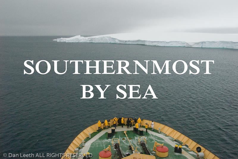
A Cruise to the Antarctic Circle Takes Voyagers Past the Last Land on Earth

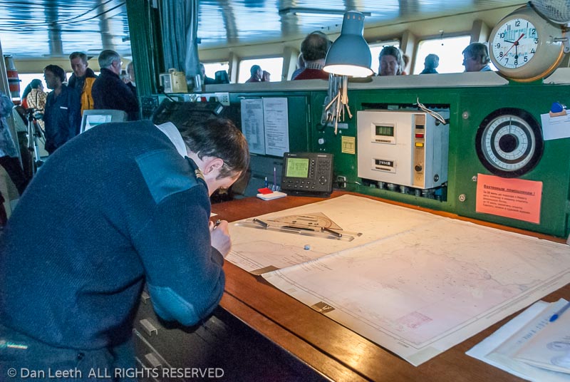
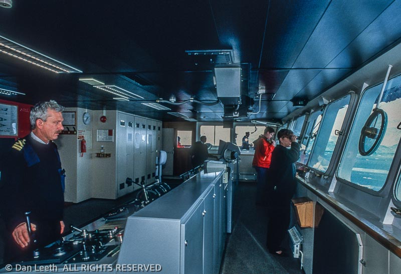
            Two nautical charts lie spread across the ship’s navigation table.  Both indicate we are traversing “unsurveyed waters.”  Concerned, the captain maintains a heading that overlaps a solitary line of depth soundings.  Although a veteran of Antarctic waters, he has never before sailed this channel.

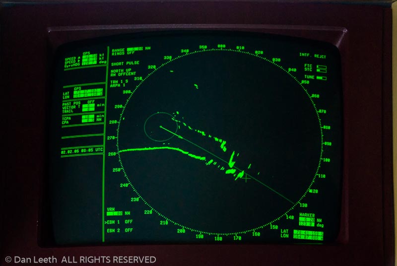
            Visibility diminishes with dusk.  Heavy snow begins to fall.  The dime-sized flakes plaster windows on the bridge making it difficult to discern the icebergs that clog the channel.  The floating obstacles, however, show clearly on radar.  Images of ice paint the monitor with splotches of cold orange. 

            One massive, tangerine glob looms dead ahead.  The scale registers a distance of three kilometers. 

            Then two.  

            At one kilometer, the captain breaks the silence with a whispered order.  The helmsman flicks the wheel, and the ship begins angling. 

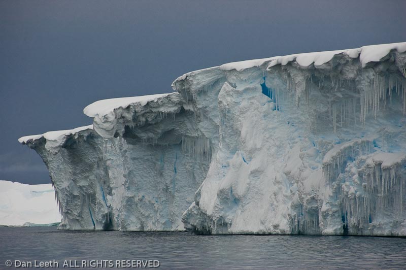
            Through a shroud of fog and snow, a ghostly apparition reveals itself as a tabular iceberg, a form unique to the Southern Ocean.  Its sheer sides rise a hundred feet to a top that stretches flat and wide as a Kansas homestead.  Once again, I stand awestruck by the humbling magnitude of Antarctica.

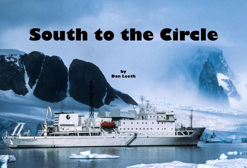
            Our polar-class cruise vessel is bound for the Antarctic Circle, the dashed line that girds the bottom of the globe.  The route there takes us past the most remote and uninhabited land on the planet. 

            Antarctica was not sighted until 1820.  Another 79 years passed before anyone wintered on its surface.  Explorers soon arrived in a deadly quest for the southern pole.  Scientists followed.  Until recently, the land’s only tourists were those who could afford five-figure fares.  Now, prices have plummeted, and for about the cost of a Caribbean escapade, I booked a Marine Expeditions’ cruise to the seventh continent. 

            Antarctica is shaped like a manta ray with a curving tail.  A 600-mile stretch of ocean separates the stinging end from the tip of South America.  Through this gap known as the Drake Passage churn the roughest seas on earth.  Negotiating the “Slobbering Jaws of Hell” is the true toll of admission to the last land on earth. 

            “Stow everything before you turn in,” the guides warn.  “Also, securely latch cabin portholes.”

            Leaving from Ushuaia, the Argentine city on Tierra del Fuego, the ship first navigates the placid waters of the Beagle Channel.  Then, sometime in predawn darkness, we hit the open ocean. 

            For two days we do the Drake Shake, rocking and rolling through latitudes where no appreciable land tempers nautical might.  Winds howl at near gale force.  Waves explode over the bow, sending a shrapnel of ocean spray higher than my fourth deck window.  Swells rise between 15 and 40 feet, their estimated size varying with the amount of sea sickness the observer is suffering. 

            “This is not too bad for the Drake,” a staff member assures me.  “I’d say it is fairly typical.” 

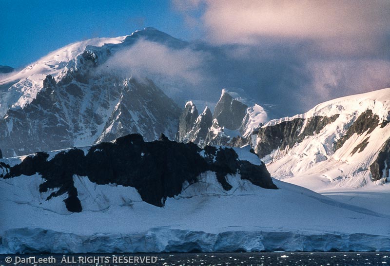
            Our second day from South America, we enter the cold waters of the Southern Ocean.  The following morning, I awaken to views of a coastal archipelago.  Sedated by land, the seas have calmed to a gentle chop.  Wisps of cloud float around mile-high summits.  Angular ridges poke like chocolate shards from glacial frosting.  Cracked, fissured, smooth and choppy, the ice flows in frozen slabs to the sea.  It looks as though a range of Everests jut straight from ocean blue.

            “This is like childbirth,” observes one motherly passenger.  “Getting here is labor.  Now we cradle the joy of parenthood.”

            An unruly child, Antarctica is on average the coldest, windiest, highest and driest of the seven continents.  Although its surface holds 70 percent of the world’s fresh water, the polar plateau receives about the same precipitation as Death Valley.  Owned by no one, the land has no indigenous human population, and animals visit only briefly to molt and reproduce.  It remains the only continent without a Holiday Inn.

            In this region of extremes, sailing routes depend on weather, and shore landings are at the whim of wind and waves.  Although the guides advise us to be flexible, our initial landfall comes on schedule. 

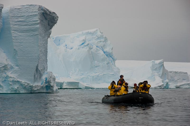
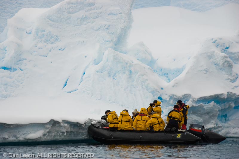
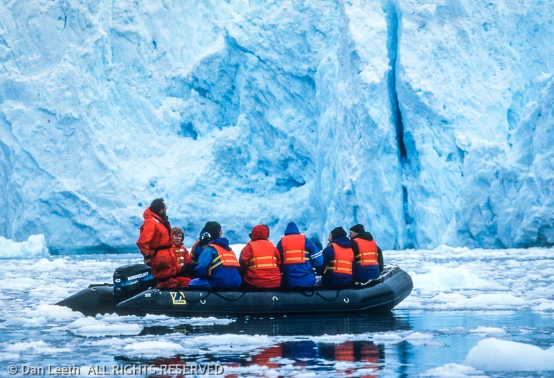
            We assemble on deck in predesignated groups.  When mine is called, I join nine others in an inflatable Zodiac.  The driver guns the outboard, and a quarter mile later, we bump dry land.  With one step, I join the exclusive fraternity of people who have touched Antarctica. 

            Our first frat party is a black-tie affair hosted by a delegation of two-foot-tall penguins.  Garbed in feathery tuxedos, they strut like aristocrats at a fund raiser.  The majority of residents are chicks still covered in gray down, but a few adolescents are beginning to sprout head feathers.  The hairdos make them look as bizarre as punk rockers at an opera. 

            At nearby Paradise Harbor, we take Zodiacs on a cruise through an inlet cul-de-sac that resembles an intimate version of Alaska’s Glacier Bay.  Towering crags scrape the sky.  Blankets of frozen ice drape the cirque in curtains of crystal blue.  Miniature bergs reflect in mirror-still water. 

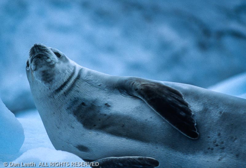
            We glide past Antarctic shags, which nest on a plunging cliff.  Nearby, thick flocks of terns flutter in the air.  Crabeater seals lounge on an ice floe.  We approach, quietly sneaking photos like a boatload of paparazzi.  The natives seem unfazed by our bold intrusion. 

            Outdoor temperatures along the peninsula typically hover around freezing, and a few layers of ski clothing provide comfortable warmth.  One evening, we even enjoy an outdoor, deck-top barbecue.  The chefs grill steaks, chicken, burgers and brats while the bartender mixes drinks with ice chipped from the remnants of a small berg.  This is one picnic where brews stay cold, and ants definitely are not a problem.  

            Continuing south, we pass through the Lemaire Channel, a fjord-like corridor nicknamed “Kodak Gap.”  Here, glistening mountains ascend from the ocean in postcard-perfect artistry.  It looks as though we are sailing through the Alps after the Great Flood.  The view is nearly identical to that seen by the first mariners who plied these waters.  Apart from a handful of science bases, Antarctica remains virtually untrammeled by humankind. 

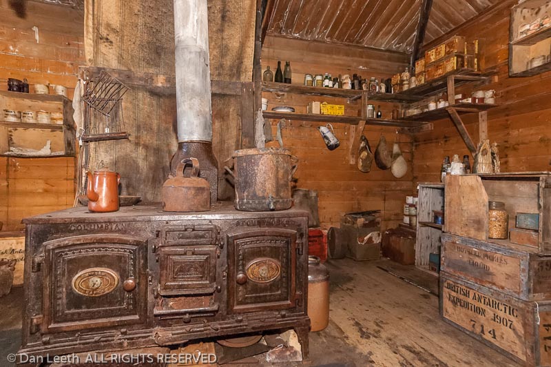
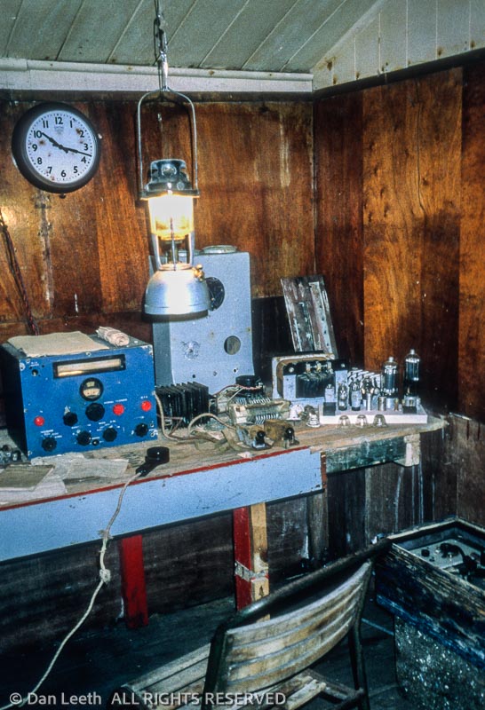
            We visit one of the continent’s earlier research stations at Port Lockroy.  Built by the British during World War II, it provided reconnaissance and weather data.  The main hut, Bransfield House, remains the oldest British structure on the peninsula.

            Now a historic site, Port Lockroy offers a glimpse of Antarctic life from a half-century past.  The unpretentious buildings were made of wood, heat came from coal-burning stoves, and communication with the outside world was by vacuum-tube radio.  Originally a crew of nine lived in spartan quarters.  Now a pair of Antarctic veterans spend the austral summer refurbishing the facility.  They also vend clothing, patches, stamps and postcards. 

            “We get over 40 tour boats each season,” says one of the pair.  “The money we collect goes toward restoration. 

            While Antarctica is becoming a more popular destination, the continent still gets only about 10,000 visitors each year.  Trip organizers have formed the International Association of Antarctica Tour Operators (IAATO) to self-regulate tourism.  Members pledge to travel safely, protect wildlife, respect protected and scientific areas and help keep earth’s last true wilderness pristine.

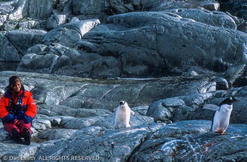
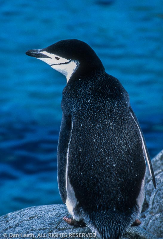
            We stop at Petermann Island where the peninsula’s three species of penguins peacefully share an integrated neighborhood.  Gentoos have snowy earmuff flashes that cross their heads from one eye to the other.  Chinstraps sport black skull caps seemingly held in place by a thin line below their beaks.  Adélies feature black noggins with their eyes ringed in white.

            As we head south, we spy more wildlife from the ship’s bridge.  Through its windows, I glimpse whales shooting plumes of vapor from blowholes.  Above the surface, albatrosses soar on glider wings.  Skuas and kelp gulls add to the aerial display. 

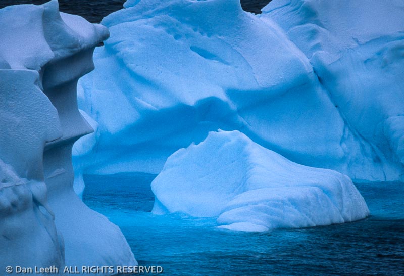
            When wildlife is absent, I admire the floating gallery of sculpted icebergs.  Some look like Monument Valley monoliths.  Others are honed and weathered like salt licks.  Many glisten Clorox white, their ice still marbled with trapped air.  The rest show pale blue, dense from years of glacial compression.  Nearly all display a band of eerie luminescence that shimmers below the waterline like neon glowing beneath a low-rider. 

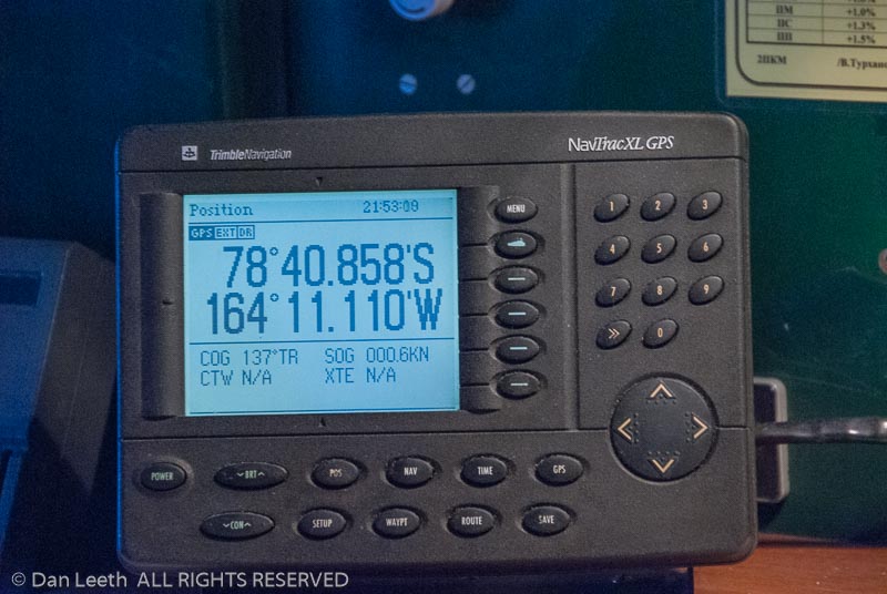
            The iceberg flotilla increases as we head farther south.  I watch our progress on the Global Positioning System’s digital display.  At a bleary-eyed 2:40 in the morning, the ship reaches 66 degrees, 30 minutes southern latitude.  We cross the circle and enter the south polar world.

            A few hours after dawn, we take Zodiacs to windswept Detaille Island.  A British research station once operated here.  Frequently frozen in, even the tenacious Brits gave up and left years ago.  Their buildings remain. 

            Near the structures, Adélie penguins waddle up a snow slope, then toboggan down on their bellies.  A hundred yards away, fur seals growl at each other.  These animals have the disposition of a linebacker, are aggressive as Ken Starr and bear the teeth of Mike Tyson.  Unlike other seals, they can run on their flippers.  We maintain our distance.

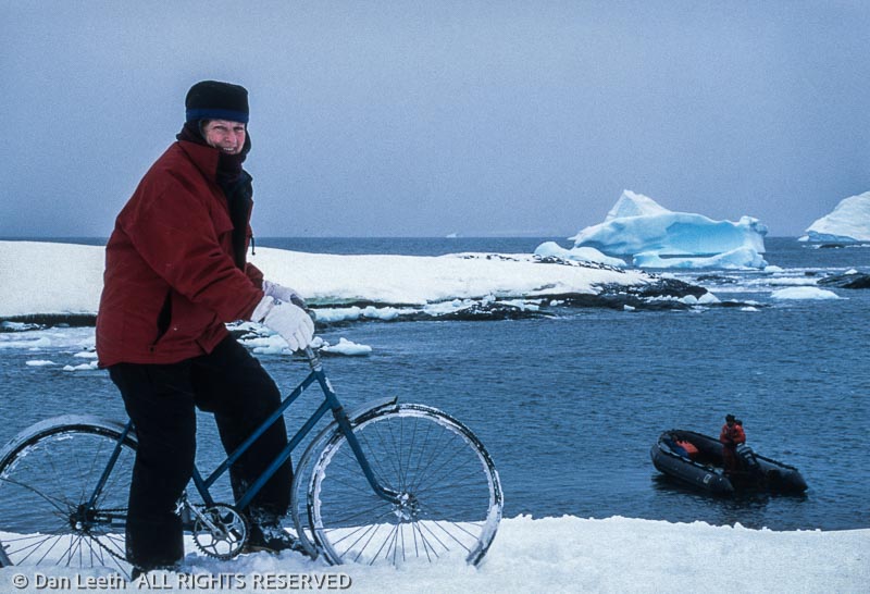
            One passenger found an old bicycle onboard, and he has it hauled ashore.  A few of us take turns posing as polar pedalers atop the two-wheeler.  For two hours, we goof-off, explore the island and view its wildlife.  Finally, time comes to return.  The crew hoists the Zodiacs aboard, and the ship turns north. 

            From his place on the bridge, the captain smiles.  A look of relief seems to cover his face.  The waters here may be unsurveyed, but he now brandishes the confidence of having sailed this way before. 

A Russian Icebreaker Carries International Cruisers to Antarctica for an Attempt to Break the Record for the Farthest South Ever Reached by a Surface Vessel

            BAY OF WHALES, Antarctica – A stifling fog shrouds the still, dark Antarctic water.  Flat-topped icebergs loom through the snowflakes and mist on either side of the Russian icebreaker.  Dead ahead, a gap in a jumbled ice wall allows passage into a narrowing inlet.  Cautiously, the Kapitan Khlebnikov creeps forward.

            Second mate Stanislaw Ul’uanov attempts to plot the ship’s course on the admiralty chart, but his position line has reached the map’s southernmost margin.  The vessel is literally sailing off the charts.

            “Ladies and gentlemen, about 30 seconds ago we reached a position of 78 degrees, 40.572 minutes south,” announces Robert Headland, archivist for Britain’s Scott Polar Research Institute.  “We are out of the position where there are reliable soundings.  To avoid touching, the captain is taking precautions.  I’ll keep you informed.”

            The icebreaker, leased by Quark Expeditions, presses southward in an attempt to break the nearly 95-year-old record for Antarctica’s southernmost point reached by a surface vessel.  The existing mark was set February 15, 1911, by the Norwegian ship Fram, which had just dropped off Roald Amundsen’s party for their own record-setting push to be first to the South Pole. 

            Measuring solar angles with a sextant, First-Lieutenant Thorvald Nilsen of the Fram determined their southernmost position to be 78 degrees, 41 minutes.  The Kapitan Khlebnikov, which comes equipped with the far more accurate satellite Global Positioning System (GPS), lies less than half a nautical mile away from the historic milestone.

            Relishing this rare 21st-century opportunity to set a new geographical record, nearly all of the 93 passengers have taken watchful positions around the ship.  The heartiest huddle like penguins outside on the bow.  Others watch from the warmth of the bridge, standing at the windows or lingering by the navigation station where they gaze at the GPS readout.  Its display now shows 78º40.656.’

            The southernmost-by-sea quest caps a 24-day expedition to the seldom-cruised Ross Sea.  Most voyages to the Great White South begin and end in South America, exploring only the northern reaches of the Antarctic Peninsula.  Departing from New Zealand, Quark’s “Great Antarctic Explorers” voyage heads to where explorers Ernest Shackleton and Robert Falcon Scott began their journeys to the South Pole nearly a century ago.  Their historic huts, still stocked with original foodstuffs, remain preserved in Antarctica’s freeze-dried environment.

            Passengers range from retired teachers to working professionals and hail from nine different nations.  All hold a keen interest in Antarctica.  In addition to visiting historic huts and modern science stations, they welcomed the opportunity to march with penguins, search for whales, sidle past sea lions, sail with seals, amble by albatrosses and scope scores of sea birds.  They also helicoptered over icebergs, picnicked on sea ice and partied under the midnight sun atop the Ross Ice Shelf.  Then it was on to the Bay of Whales.

            “This is the closest body of water to the South Pole.  That’s why Amundsen set his base up there in his rush to beat Scott to the pole,” explains Quark executive Prisca Campbell.  “The plans for our trip are to reach the Bay of Whales in optimum weather and ice conditions to break the record.  We think we’ve got the right vessel, and we have a captain with extraordinary expertise and years of experience.”

            Clad in a navy blue sweater, Capitan Victor Vasil’yev, a short, middle-aged Russian with closely cropped hair, stares out a window on the starboard side of the bridge.  A helmsman sits at the wheel in the center.  Second mate Ul’uanov, a lad in his 20s, scurries at the back between the green-glowing radar and the now useless charts.

            “Keep the voices down so the captain can communicate with his officers in this tight navigation,” requests Quark expedition leader Shane Evoy.  “Keep the aisle clear so the navigator can navigate.”

            The GPS numbers slowly rise.  It now reads 78:40.728,’ less than half a statue mile short of the record.  Every six feet the ship moves south, the GPS increases by one-thousandth of a minute.

            “I almost hope we don’t make it,” British passenger Jenny Coverack whispers.  “Maybe it’s better to just let the old record stand.”

            It seems improbable that a 1911 record set by a wooden ship could still stand, but reaching the farthest south is not a reflection of horsepower and willpower.  Instead, it’s governed by the whims of nature.

            A triangular shelf of ice fed by a string of Antarctic glaciers permanently covers the southernmost 450-600 miles of the Ross Sea.  Called the Ross Ice Shelf, this floating sheet of frozen freshwater covers a 200,000-square-mile area, larger than the state of California.  Its 600-mile front consists of a sheer wall of ice cliffs that poke as much as 200 feet above the water and nearly a thousand feet below.  This is an ice cube no breaker on earth could penetrate.

            The barrier, however, does have one minor break.  Near its eastern edge rises Roosevelt Island, which breaks the glacial flow like a boulder parts water in a stream.  While some of the ice covers the island, much of the rest pushes to one side or the other.  A weakness where the flows rejoin forms a natural breach in the ice wall that varies in magnitude from year to year.  This year, the break looks big.

            Captain Vasil’yev gives an order in his native language, and the helmsman silently makes a slight turn.  The GPS reads 78º40.858,’ three football fields short of the record.  It seems so close.

            There remains one small problem.  On the ice ahead stands a group of molting Adélie and emperor penguins.  Each year, these flightless birds must replace every feather on their bodies, and during that three-week period, they have to remain out of the water and thus, do not feed.  Reaching 78º41’ may require nosing the bow into the penguins’ perch at a time in their lifecycle when these birds should be using stored reserves for making feathers, not dodging icebreakers.

            Evoy and the captain confer in hushed whispers.  An order is given and the ship turns.  Latitude readings begin to recede.

            “Kapitan Khlebnikov achieved the far southern position of 78 degrees, 40.871 minutes.  That is less than the 41 minutes achieved by Amundsen at the southern limit of southern navigation,” Headland announces.  “I do not think that we can say we beat it, but bearing in mind instrumental accuracy, I think we equaled it.  We will now assemble on the bow.”

            On the slushy foredeck, Quark staffers pour champagne.  Headland, whose heady English accent makes him sound like a Harry Potter schoolmaster, repeats his “let’s call it a tie” proclamation.  The mood is jovial.

            “Nobody celebrates failure better than the British,” chuckles New Zealand geologist Malcolm Laird.

            But all is not lost.  The ship anchors for the night near the mouth of the bay, and the next morning, the crew drops Zodiacs into the water.  These inflatable, Jacques Cousteau-style motorboats will allow another attempt at the record for the farthest south by surface vessel.  It may not have the cachet of an oceangoing ship, but a Zodiac is a vessel and it does travel on the surface.

            The fog has lifted, but snowflakes continue to fall and the sky remains stone gray.  Temperatures hover in mid 30s.  Evoy mans the motor and Headland, armed with two portable GPS units, rides near the bow.  Between them sit ten hopeful passengers. 

            The craft planes across the smooth surface toward the inlet cloaked in monochromatic shades of gray and black.  Slabs of ice resemble frozen white cakes snow-draped in vanilla frosting.  Icicles hang like crystal daggers from overhanging ledges.  Cracks, fissures and ephemeral cavities in the ice-shelf walls allow wisps of neon blue light to glow, and teal green luminescence shimmers from just below the waterline.  The Zodiac’s waterline vantage yields an inspiring, intimate view of Antarctica’s stark, imposing grandeur.

            Three minke whales spout in the smooth water.  Crabeater seals lie on the ice.  Snow petrels fly overhead, their pure white bodies visibly disappearing against the white of the ice.  Ahead, the penguins remain perched on their sloping slab.

            Evoy throttles back and quietly motors in their direction.  At a nonthreatening, 10-yard distance from the birds, he points the rubber bow of the Zodiac toward the wall and thumps into the ice.  Headland looks at the GPS.

            “Ladies and gentlemen,” he proclaims.  “Looking at the instruments aboard this vessel, we have exceeded Amundsen’s farthest south with a position of 78 degrees, 41.030 minutes.  These vessels are thus the farthest south on the planet – ever.

            Everyone gets a chance to smack the southernmost shore.  Back at the ship, the mood is even more buoyant than before.  It’s February 2, 2006 and a new mark has been set, which Headland will submit to the folks at Guinness.  Of course, the record may fall when the Kapitan Khlebnikov or another icebreaker returns in some future season, but until then, the achievement for southernmost navigation by sea belongs to the folks onboard.  Down in the ship’s bar, the drinks flow.

            Up on the bridge, the ambiance remains sober.  Captain Vasil’yev gives the order to fire the engines and the icebreaker heads north.  It’s the only direction it can go from here.